Walk 3038 - printer friendly version
Wolfhole Crag from Tower Lodge Walk
Author - Lou Johnson
Length - 9.0 miles / 14.6 km
Ascent - 1400 feet / 424 metres
Grade - moderate
Start - OS grid reference SD604539
Lat 53.9796320 + Long -2.6053028
Postcode LA2 9BN (approx. location only)
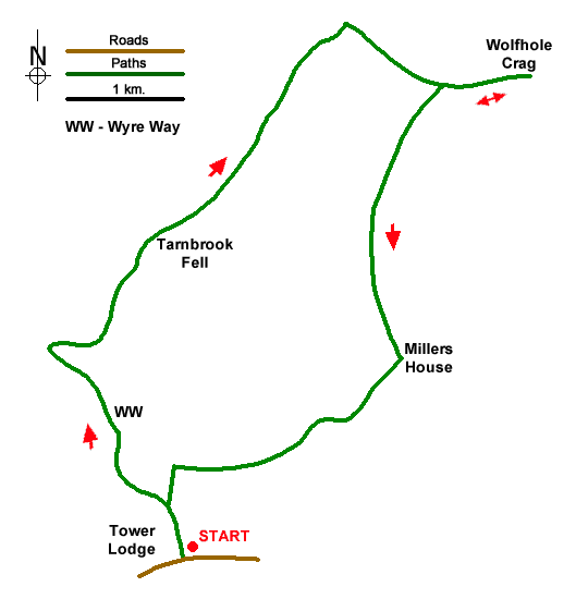
Wolfhole Crags (527 m.) lie on a moorland ridge in the Forest of Bowland and offer extensive views across the surrounding area. The route needs careful navigation and should be avoided in poor visibility. The walk follows a good track onto the ridge which is followed east to Wolfhole Crags. The descent is initially guided by a wall of fence but later requires very careful route finding with only a faint path. A short section of the walk follows the Wyre Way.
The start is small parking area just east of Tower Lodge (grid ref. SD604539). After parking cross the road to join a track to the left of the lodge as indicated by a fingerpost. You are now following the Wyre Way. After 300 metres the path turns left with adjacent sign. The onward route crosses pasture to a ladder stile. Once across the stile turn right, pass through a gate in a wall, and head downhill beside a wall to a stile. The path continues ahead to join a track between two buildings. Cross a bridge, head half-left across a field past Gilberton Farm to cross a bridge over Tarnbrook Wyre (grid ref. SD595554). Follow the farm's drive to where it bends left.
Turn sharp right along a clear track. Follow this track, keeping ahead at all junctions, climbing steadily for four kilometres to reach a metal gate (grid ref. SD618583). Turn right before the gate and follow the fence towards the rounded hill ahead. The path is wet in places but mostly you can avoid wet feet. You reach a junction of a fence and wall (grid ref. SD626578). Continue ahead for a further 500 metres with a wall on your left to reach the summit rocks of Wolfhole Crag which are marked with an OS trig column.
To start the descent, return to the junction of wall and fence. Head through the kissing gate and turn left to Millers House. Follow the fence on your left downhill. As you descend the fence becomes a wall as you cross Brennand Great Hill. Continue the descent to the ruins of Millers House (grid ref. SD622555). Once a hive of activity, today a few millstones give a clue to the former industry. There is little evidence of the concessionary path marked on OS maps. However, head southwest and after 500 metres you will reach a wall. Turn right along the wall and follow the wall for just over two kilometres to reach a gate and ladder stile (grid ref. SD603543). Turn left and descend to Tower Lodge.
Messaging & Social Media
Message Walking Britain and follow the latest news.

Mountain Weather
Stay safe on the mountains with detailed weather forecasts - for iOS devices or for Android devices.