Cleeve Common & Belas Knap from Winchcombe
Cotswolds Walk
Region - Cotswolds
County/Area - Gloucestershire
Author - Lou Johnson
Length - 10.0 miles / 16.3 km Ascent - 1200 feet / 364 metres
Time - 6 hours 10 minutes Grade - moderate
Maps 

| Ordnance Survey Explorer OL45 | Sheet Map | 1:25k | BUY |
| Anquet OS Explorer OL45 | Digital Map | 1:25k | BUY |
| Ordnance Survey Explorer 179 | Sheet Map | 1:25k | BUY |
| Anquet OS Explorer 179 | Digital Map | 1:25k | BUY |
| Ordnance Survey Landranger 163 | Sheet Map | 1:50k | BUY |
| Anquet OS Landranger 163 | Digital Map | 1:50k | BUY |
Walk Route Description
Click image to visit gallery of 9 images.
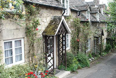
This route starts in the small, unspoilt Cotswold town of Winchcombe. Here you will still find butchers, bakers and greengrocers so the general feeling is one of a working community despite the attractive buildings that line the streets. The walk continues onto higher ground of Cleeve Common before completing the circuit using the Cotswold Way. Please note (October 2009) that the Cotswold Way has been re-routed in the Belas Knap and Cleeve Common area since this description was written. Please refer to maps and follow local signage.
There is a public car park located on Back Lane (Grid ref. SP023284). From here locate High Street reached by following Cowl Lane south from the car park. Turn right along Abbey Terrace (a continuation of High Street) and then first left down Vineyard Street. Just after reaching the bottom of the hill take the signed path on your right (Grid ref. SP024280), which leads across fields to a road. Turn right along the road to a junction where a signed footpath (Grid ref. SP017276) takes you through fields alongside the River Isbourne to reach Postlip Mills. Walk through this factory complex. Care is needed to locate the onward footpath which is at the western end of the factory area (Grid ref. SP008272).
After having successfully located the path follow it for a short way to where the path turns southwest. On the right is a smaller path which follows the field boundary towards Postlip Hall, which is partly hidden on your right. Reaching a driveway, continue straight ahead on the Cotswold Way. The Cotswold Way bears half right and then reaches a junction of paths (grid ref. SO997267). Go left here. This leads you through a narrow belt of trees to reach and open area in a valley (Grid ref. SO995266).
There are many paths and care is needed to make sure you take the correct one, which is the Cotswold Way heading roughly northwest. This well made path leads steeply uphill across a golf course to reach the club house. The Cotswold Way in this area is waymarked and once located is easy to follow. However there are sections when you need to make a few assumptions and a good map is essential.
The Cotswold Way follows an undulating route past the 317m. trig point where excellent views across the surrounding countryside and Cheltenham are on offer. Staying on the Cotswold Way descend slightly to reach a wide path (Grid ref. SO984260) heading SSE towards a group of radio masts, which are the next objective. Follow this path to the masts from where the paths on the ground do not exactly match those shown on maps. The best option is to walk ESE to the boundary fence (Grid ref. SP000246) to join the Cotswold Way to Wontley Farm (Grid ref SP008246). Turn left here along a track to Belas Knap. This restored long barrow is an interesting feature and typical of this kind of structure.
The path turns sharp left here and takes a rather circuitous route to reach a lane (Grid ref. SP022261). Turn right along the lane. Take the second signed path on your left past Humblebee Cottages to Wadfield Farm. The path goes to the right of the buildings here with the onward route a well-trodden path with Winchcombe in sight ahead. Reaching a lane (Grid ref. SP025277), turn left and walk into the town. At the top of Vineyard Street, turn right and return to the car park along Cowl Lane.
Other walks nearby
| Walk 1949 | Nottingham Hill | easy/mod | 4.5 miles |
| Walk 3327 | Temple Guiting & Cutsdean from Stanway | moderate | 10.0 miles |
| Walk 3063 | Stanway & Snowshill circular | moderate | 8.0 miles |
| Walk 2094 | Snowshill Circular | easy | 4.4 miles |
| Walk 2168 | The Slaughters | easy/mod | 8.6 miles |
| Walk 3072 | Broadway, Stanton & Laverton | easy/mod | 7.5 miles |
| Walk 3250 | The Broadway Tower from Broadway | easy/mod | 5.0 miles |
| Walk 1853 | Bredon Hill from Kemerton | easy/mod | 5.2 miles |
| Walk 2495 | Bredon Hill Circular | moderate | 10.6 miles |
| Walk 2402 | Bredon Hill from Elmley Castle | easy/mod | 5.5 miles |
Recommended Books & eBooks
The Cotswold Way
 Guidebook to walking the Cotswold Way National Trail. Between Chipping Campden and Bath, the 102 mile route explores the Cotswolds AONB. Described in both directions over 13 stages, the Cotswold Way can be walked year round and is suitable for beginner trekkers. Includes separate OS 1:25,000 map booklet of the route.
More information
The Cotswold Way Map Booklet
 Map of the 102 mile (163km) Cotswold Way National Trail, between Chipping Camden and Bath. This booklet is included with the Cicerone guidebook to the trail, and shows the full route on OS 1:25,000 maps. The trail typically takes two weeks to walk, and is suitable for walkers at all levels of experience.
More information
Messaging & Social Media
Message Walking Britain and follow the latest news.

Mountain Weather
Stay safe on the mountains with detailed weather forecasts - for iOS devices or for Android devices.