Walk 3094 - printer friendly version
Norber & Norber Erractics Walk
Author - Lou Johnson
Length - 6.3 miles / 10.2 km
Ascent - 950 feet / 288 metres
Grade - easy/mod
Start - OS grid reference SD746692
Lat 54.1180340 + Long -2.3900773
Postcode LA2 8EA (approx. location only)
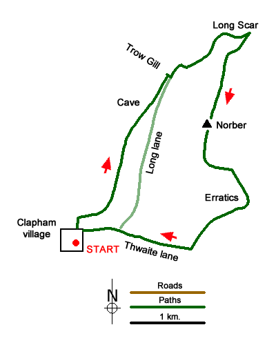
The limestone 'Three Peaks' country to the north of the Yorkshire Dales village of Clapham is explored in this walk with the high ground of Norber and the Norber Erratics the main objective of the route. The walk also offers fine views of Ingleborough and Pen-y-ghent, two of the Yorkshire 'Big Three' peaks. The start is the large pay and display car park in Clapham (Grid ref. SD746692). Alternative on-street parking is also available in the village although please park with consideration of residents and businesses.
Two alternative routes area available for the first section of the walk. The first option is to leave the main car park and turn right. Almost immediately turn left over the small footbridge across Clapham Beck and then head right up the road to reach the entrance to the Ingleborough Cave Estate. A charge of £1 per adult is levied but the walk through the grounds is pleasant an undemanding. After a section through woodland the well-maintained path enters the Clapham Beck valley and continues past Ingleborough Cave. 500 metres past the Cave and just before the main path to Ingleborough enters Trow Gill (grid ref. SD757714), take the signed footpath on the right. A short steep ascent leads you to Long Lane.
The other choice of route leaves the car park, turns right and continues up to reach Clapham Paris Church. Bear right and then left around the churchyard and follow the track (Thwaite Lane) up through tunnels to reach a junction with Long Lane (grid ref. SD751694) after 500 metres or so. Turn left here and continue up Long Lane, which as the name suggests is a lengthy uphill walk. Reaching the point where the path from the foot of Trow Gill comes in from the left (grid ref. SD757714), both options then continue on the same route.
Continue up Long Lane to reach a gate (grid ref. SD758716). After passing through the first gate bear right continuing up to a further gate (grid ref. SD761716). You are now able to enjoy a wonderful view across to Ingleborough on your left. After the second gate, you reach a junction of tracks. Bear left here following the waymark post. Continue round Long Scar following the clear track to reach another waymark post (grid ref. SD767720), which is close to a junction of tracks, from where there is a fine view across extensive limestone pavements to Pen-y-ghent.
Retrace your steps along the track and bear left onto a track. Ignore the track going left and continue over Long Scar to reach the point where an obvious cairn on Long Scar is to your immediate right (grid ref. SD765718). Leave the track and follow a path heading south opposite the cairn. Your next objective is the highest point on Norber (grid ref. SD762708). There are many sheep trods and paths across this open area. To reach this point follow suitable paths and trods to reach the highest ground to your left. You soon see a cairn and this provides a suitable guide to reach the highest point.
To continue, walk roughly south for about 600 metres crossing limestone outcrops and pavements to reach a shallow gulley (grid ref. SD762703). Bear left down this valley following a feint track to reach a ladder stile at grid ref. SD765702). Cross the stile into a large field which is dotted by many erratic boulders dumped by the receding glaciers. The route I followed was to head down the large field following a clear grassy path towards a wall (grid ref. SD768699). Bear right along the wall (with the wall to your immediate left) and continue down a section with a crag to your left. Shortly after you see a four-way fingerpost at grid ref. SD766697).
Go straight ahead at the fingerpost following the path below Robin Proctor's Scar and across a large field to reach Thwaite Lane (grid ref. SD760691). Turn right along Thwaite Lane to reach the junction with Long Lane. Continue ahead signed to 'Clapham' and descend through tunnels back into Clapham village.
Messaging & Social Media
Message Walking Britain and follow the latest news.

Mountain Weather
Stay safe on the mountains with detailed weather forecasts - for iOS devices or for Android devices.