Walk 3095 - printer friendly version
Stob Ban (Mamores) Walk
Author - Peter Smyly
Length - 6.0 miles / 9.8 km
Ascent - 3000 feet / 909 metres
Grade - mod/hard
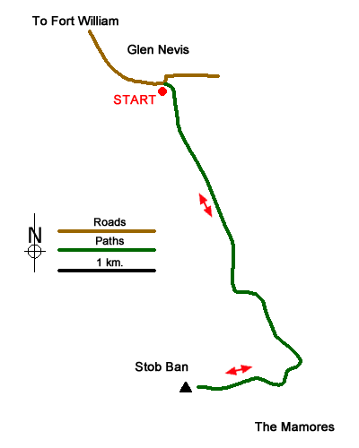
Start - OS grid reference NN145683
Lat 56.7692400 + Long -5.0369395
Postcode PH33 6SY (approx. location only)
When seen from the Glen Nevis valley, the white quartzite atop the shapely peak of Stob Ban can be mistaken for snow. Stob Ban (meaning white peak) is one of the Munros in the Mamores range of the north-west highlands of Scotland. It may not hold the same attraction as Ben Nevis across the glen, and it sees far fewer walkers, but this is a very satisfying mountain to climb and it has all the attributes you would expect of one of the more rugged and picturesque mountains in Scotland.
It is described here as a "there and back" route rather than a circular one. It is strongly recommended that you choose a clear day for the walk as there are magnificent views especially of the other peaks in the Mamores range and Ben Nevis, Carn Mor Dearg, Aonach Mor and Aonach Beag (the "Lochaber giants", all of them over 4,000 feet). The route also reveals Stob Ban itself at its best, its rugged attributes seen to dramatic effect with its cliffs and buttresses seen on the approach route to the bealach. Then the same view is starkly apparent to the right of the narrow and steep ridge leading to the top from the bealach, a prospect that some may find intimidating but the route is not as tricky as it might appear.
The route itself requires little by way of description. Start in Glen Nevis at the car park near to Achriabach (grid ref. NN145683) and follow the road for a short distance up the valley to locate the start of the stalker's path. The path leads steadily up the glen between Stob Ban on the right and Sgurr a' Mhaim on the left and the views get increasingly better the higher up you go. At one point the path overlooks a gorge on the right with only a steep slope separating the two before a series of bends to the left and then begins the ascent to the bealach and thence on to the top.
Messaging & Social Media
Message Walking Britain and follow the latest news.

Mountain Weather
Stay safe on the mountains with detailed weather forecasts - for iOS devices or for Android devices.