Walk 3097 - printer friendly version
Markyate and Flamstead Circular Walk
Author - Donald Morton
Length - 7.0 miles / 11.4 km
Ascent - 400 feet / 121 metres
Grade - easy/mod
Start - OS grid reference TL079145
Lat 51.81872 + Long -0.43599123
Postcode AL3 8BN (approx. location only)
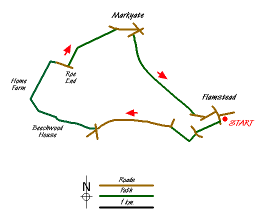
This Hertfordshire walk starts in the pretty little village of Flamstead, just off the A5 near junction 9 on the M1. Despite its proximity to these major routes it is quiet and peaceful and secluded. Park behind the Village Hall to the South of the Church (Grid Ref TL079145). From here go up the steps into the churchyard surrounding the fine old church dating in parts from the 12th Century. Turn left and walk along the boundary of the churchyard to come out in Trowley Hill Road; There are some old cottages just to the right and beyond the churchyard the Three Blackbirds pub, but our route is to the left and immediately right down an enclosed footpath (public footpath 32/Chiltern Way). This comes out through a barrier to go straight on across a field and come out at a lane. Turn left for a 100yards then right on a footpath going downhill. In the bottom of the valley, at a finger post, leave the Chiltern Way and turn right along a bridleway. Follow this along the bottom of the valley to a lane. Turn left and follow this quiet lane, still in the valley floor, to a five way junction.
Cross the road and go through the gates of Beechwood House School. Walk past the Victorian Lodge on the right and up the drive which is also a public footpath. For the next 11/2 miles or so you will be walking through a landscape created by Lancelot 'Capability' Brown as the setting for the 18th Century mansion, formerly the home of the Sebright family, and now a prep school. When a footpath comes in from the left you join the Hertfordshire Way and continue on, to swing right and past the front of the mansion - you may wish the school authorities could find somewhere else for the staff car park. Once past the mansion the tarmac turns to gravel - you are going to leave by the tradesman's entrance - and continues on a 'Private Road', 'No Throughway No Horses'. This gravel track goes through gates at Kennels Lodge. Here turn right down a broad track past Home Farm (B&B) which eventually turns to tarmac as you follow it right past Holly Bush Lodge. After passing Roe End Lodge on the left and just after Spring Cottage on the right, turn left on Public Footpath 17 Markyate 11/2. Walk down the field edge with hedge on right. At the corner go through a hedge gap and continue straight on down a field break and later with a hedge on the right, and a view of Markyate ahead. At the field end turn left and walk down an enclosed track to a road. Turn right and walk through an estate to the town centre coming out at the Sun Inn. This stands on the High Street which follows the line of the Roman Watling Street halfway between St Albans and Dunstable. Now bypassed, the High Street to the left of here has many 16th, 17th, 18th and 19th Century buildings from its earlier periods of prosperity as a travellers' rest.
Opposite The Sun turn right and then right again down Pickford Road. A little way up here turn left on footpath signed Flamstead 11/2 beside house number 19. Go up a sunken lane through a wooden barrier and straight on with allotments and hedge on the right. In theory from here to Flamstead should be a straight walk above the valley of the river Ver starting its journey to Verulanium - St Albans. However it might not be totally straightforward. At the end of the first field go left and right to continue on same line again with hedge on right. Where the hedge ends (goes right) you are confronted by a wide arable field. The broken finger post and supporting waymarks point straight ahead, and the route should have been restored by the farmer or re-trod by walkers coming before you. If you are out of luck, then note on the far side a hedge running between pylons on the right and a hedge coming forward on the left; aim for a point about a quarter away along from the left end is slightly left from your previous line. This should bring you to a hedge gap - look out for it as you go down and up over the field. Go through the gap and straight over the next, arable, field. This time if the path is not clear aim for the highest tree in the hedge ahead where you will find a metal kissing gate. Go straight on with fence on right to another kissing gate and stile. Go along the field edge with hedge on left, over a stile, straight on down a green lane to come to a lane - Friendless Lane! You are now on the edge of Flamstead and you can see the church with its distinctive narrow spire, a characteristic 'Hertfordshire spike'. You reach it by turning left in the lane and left again and then right to the road junction at the 16th Century Three Blackbirds. Opposite the pub is a display board with the history of the village and the several places of interest in it. If you have time to spare a little extra wander round is well worth it, particularly on Sunday afternoons in July through September when the church is possibly open.
Messaging & Social Media
Message Walking Britain and follow the latest news.

Mountain Weather
Stay safe on the mountains with detailed weather forecasts - for iOS devices or for Android devices.