Walk 3217 - printer friendly version
Bewdley and Snuffmill Dingle Walk
Author - Peter Lane
Length - 5.0 miles / 8.1 km
Ascent - 650 feet / 197 metres
Grade - easy
Start - OS grid reference SO794743
Lat 52.366359 + Long -2.3039622
Postcode DY12 1PX (approx. location only)
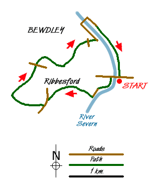
A pleasant Worcestershire walk along the River Severn and into Ribbesford Woods following some of the Worcestershire Way. Visiting the historic town of Bewdley along the River Severn, this walk offers plenty of opportunity to take a break and explore this interesting place, have a meal, a drink or even an ice cream!
Start at the Blackstone picnic site just off the A456 Bewdley bypass at grid reference SO794743. Walk down to the River Severn and just before the river, climb the steps to the road bridge and cross the River. Do not cross the road (unless you want to catch a closer look at Blackstone Rock, popular for abseiling) but drop down to the opposite bank via the footpath. Continue downstream along the river bank through a Country Park. Reaching the B4194, continue for a few metres and then cross to a broad tree lined avenue signposted to Ribbesford Church. Enter the churchyard and then climb the steep footpath out of the churchyard that continues all the way up to a country lane as the Worcestershire Way.
Turn briefly left uphill on the country lane and then right in a few metres along a footpath (leaving the Worcestershire Way). The path follows the right side of a field until it enters a wood. The path is fairly well defined and emerges at a stile at the end of the wood. Turn right and downhill towards Park Farm. Head straight for the farm and on reaching the fence, don't cross but turn left and take the stile by the cypress hedge around the side of the farm. Follow the fence closely to your right to the ever louder sound of the A456 Bewdley bypass!
Cross the bypass and directly opposite is a footpath - it may not be very clear, or even signposted (signpost lying on the ground July 2008), but it is there right at the end of the Armco! Walk through some dense wood and drop down to a pair of footbridges. You are now in the delightfully named Snuffmill Dingle. Cross both bridges and head down the Dingle, partly on a dilapidated boardwalk (take care in case of missing sections and rotten wood). At the end of the Dingle, cross the footbridge and head up the steep steps opposite. Emerging at a kissing gate and a field, head down the open field towards Bewdley.
At the next kissing gate continue and at the junction turn left following the sign to Ribbesford Circular Trail and Bewdley ½ mile sign on the path that curves to the right. Go through the gate at the bottom of the hill, follow the Worcestershire Way marks, cross the planks over the stream and after a short distance the path turns sharp right. Continue down a picturesque alley into Bewdley. Emerge onto a main road and turn briefly right and then left down Lax Lane to the River Severn.
Walk along the bank and enjoy the picturesque scene. Take the opportunity to explore Bewdley before crossing the Town Bridge and returning along the east bank. Stay close to the river and after following the road for a few hundred metres, take the footpath that follows the riverbank back to the start point.
Messaging & Social Media
Message Walking Britain and follow the latest news.

Mountain Weather
Stay safe on the mountains with detailed weather forecasts - for iOS devices or for Android devices.