Walk 3256 - printer friendly version
Great Bircham & Fring Circular Walk
Author - Lou Johnson
Length - 8.4 miles / 13.7 km
Ascent - 400 feet / 121 metres
Grade - easy/mod
Start - OS grid reference TF769325
Lat 52.8609130 + Long 0.6262477
Postcode PE31 6XS (approx. location only)
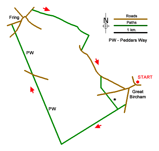
This walk from Great Bircham (Norfolk) explores the countryside to the west and north of the village. The route includes a section of the Peddars Way along a former Roman Road, visits the hamlet of Fring, continues across low hills before passing Bircham windmill. The walk follows quiet lanes, tracks, bridleways, and paths with no navigational issues.
The start is Great Bircham Social Club (grid ref. TF769325) on Church Lane, Great Bircham where parking is available. After parking return to Church Lane and turn left to reach the B1153. Turn left and continue south past the King's Head Hotel. Ignore Crow Lane on the left and continue past the village sign on the left. Just past this sign fork right onto a wide gravel track. Follow this track for two kilometres to reach a cross track with a fingerpost indicating the Peddars Way (grid ref. TF748309).
Turn right and follow the old Roman Road north. After two kilometres you reach a road. Cross the road and continue following the Peddars Way north. Cross the next road and shortly afterwards you reach a lane (grid ref. TF733345). Turn right, bear left at the next road junction, and walk through the hamlet of Fring. Ignore lanes to the left and right and continue along the road signed to Docking. Continue for 300 metres beyond the road signed to Bircham and take the clear track on the right (grid ref. TF739350).
Follow this bridleway for about two kilometres and turn right onto a footpath (grid ref. TF756342). Follow the path with hedge right down to Bircham Road. Turn left and after a kilometre fork left onto a narrower lane. This leads south to pass Bircham Windmill on your left. Continue ahead to the next T-junction. Go straight across and follow the track initially enclosed by hedges for 600 metres to reach a cross track used for the outward section of the walk. Turn left and retrace your steps back to the start.
Messaging & Social Media
Message Walking Britain and follow the latest news.

Mountain Weather
Stay safe on the mountains with detailed weather forecasts - for iOS devices or for Android devices.