Walk 3257 - printer friendly version
Cirencester & Stratton Circular Walk
Author - Lou Johnson
Length - 4.7 miles / 7.6 km
Ascent - 200 feet / 61 metres
Grade - easy
Start - OS grid reference SP025018
Lat 51.7149250 + Long -1.9652141
Postcode GL7 1EB (approx. location only)
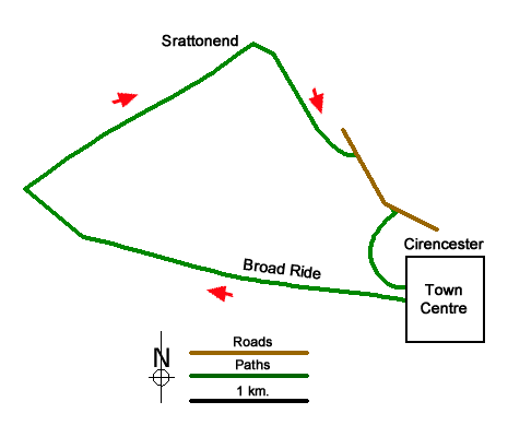
This Cirencester walk offers you the opportunity to exploring this fine town with its many interesting stone buildings before continuing through Cirencester Park and out into the countryside lying northwest of the town to the outskirts of Stratton. The return follows a series of paths around the edge of the built-up area back to the start.
There is a large pay and display car park at the Forum in the centre of Cirencester (grid ref. SP025018). After parking walk to the northern end of the car park where a black finger post points you along North Street towards the Town Centre. Turn left into Market Place where there are many fine buildings. Continue straight ahead into Castle Street and first right into Silver Street. Follow the road to the left to join Park Street which soon bends to the right. Take the next road on the left (Cecily Hill) and continue to Cirencester Park gate (grid ref. SP018021).
Continue ahead up the broad path and later over grass up the Broad Ride for two kilometres to reach Pope's Seat (grid ref. SO999024). From here fork right with trees to your immediate right and the polo field to your left. Turn right along a clear track to a gate (grid ref. SO995029). Immediately after the gate take the right-hand track and follow this with hedge on your right. Continue ahead for just under two kilometres following the track as it bends to the right to pass Stratton End on your right (grid ref. SP011038).
Take the fenced path opposite with an adjacent fingerpost. After 400 metres you reach Barn Way (grid ref. SP013034). Turn left and almost immediately right into Donside. At the end of this cul-de-sac pass through the stile and follow the path half left across a field to reach the A435 (grid ref. SP017031).
Turn right along the A435. After 300 metres fork right before the filling station into Gloucester Street. After 120 metres turn right down a footpath with a stream on your left. After 320 metres you reach Barton Lane (grid ref. SP018024). Turn right and then left onto a tarmac path. Pass an open-air swimming pool on your right and continue to reach Thomas Street. Turn right and then bear right into Park Street before retracing your steps back to Market Place and the car park.
Messaging & Social Media
Message Walking Britain and follow the latest news.

Mountain Weather
Stay safe on the mountains with detailed weather forecasts - for iOS devices or for Android devices.