Walk 3260 - printer friendly version
Butser Hill Circular Walk
Author - Lou Johnson
Length - 6.9 miles / 11.2 km
Ascent - 700 feet / 212 metres
Grade - easy/mod
Start - OS grid reference SU712200
Lat 50.9750210 + Long -0.9872521
Postcode GU31 5SP (approx. location only)
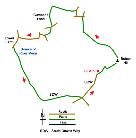
This Butser Hill walk explores the Hampshire countryside lying to the west of this excellent viewpoint. The route follows tracks and quiet country lanes which provide a pleasant insight into the rural nature of this part of Hampshire. Along the way the walk passes the source of the River Meon before joining the South Downs Way which leads you back to the start.
The start is the large car park on the west side of Butser Hill (grid ref. SU712200). From the car park take the footpath up past the public toilets and continue through the metal gate to follow the tarmac driveway. Follow the driveway past the radio mast (on your left) and continue over grass to reach the trig column (grid ref. SU717203). Take some time to enjoy the extensive view.
From the trig point follow a wide grassy path north (with fence on your right). The path descends the northern flank of Ramsdean Down swinging west and then northwest to reach a track (grid ref. SU706212). Bear right up the track to reach Oxenbourne Lane (grid ref. SU706217). Turn left and then take the first lane on the right. After 200 metres turn left onto a track (sign hidden in the undergrowth on the left). Follow this track for 800 metres to reach a junction of several tracks (grid ref. SU696220).
Turn left along Cumber's Lane to reach Oxenbourne Lane again (grid ref. SU696214). Turn right and then first left through a metal gate to follow a track which soon passes a pond on your right and a cottage. Continue ahead to Harvesting Lane. Turn right and continue to the next junction (with a thatched cottage on your right. Bear left here re-joining Oxenbourne Lane. Continue along this lane for about a kilometre to reach a T-junction (grid ref. SU685210).
Turn left (signed to Clanfield). And after 200 metres turn left through a kissing gate onto a signed footpath (grid ref. SU684208). Cross a small field and then continue on the clear track through the yard of South Farm to cross a bridge over the source of the River Meon (grid ref. SU685205). Follow the track south to reach Upper Barnes (grid ref. SU689196). After Upper Barnes, the track becomes grassy and climbs steadily to reach the South Downs Way (grid ref. SU693190).
Turn left along the South Downs Way. Pass an equine centre on your right and continue ahead to reach a road. Bear left and continue along the South Downs Way. Where the lane forks, keep right, and continue back to the start.
Messaging & Social Media
Message Walking Britain and follow the latest news.

Mountain Weather
Stay safe on the mountains with detailed weather forecasts - for iOS devices or for Android devices.