Walk 3310 - printer friendly version
Washington to Littleton Farm by the South Downs Way Walk
Author - Barry Mackie
Length - 13.0 miles / 21.1 km
Ascent - 1400 feet / 424 metres
Grade - moderate
Start - OS grid reference TQ120127
Lat 50.902922 + Long -0.4085644
Postcode RH20 4AS (approx. location only)
This linear West Sussex walk along the South Downs has some great views throughout. Highlights include a complete crossing of the Arun Valley. Most guidebooks describe the Washington section (heading west) along the South Downs Way as finishing at Houghton Bridge and this is a logical place to stop. Doing this though might just lead to a real feeling of leaving the walk "half done" by finishing in the middle of the Arun Valley. The route described here ensures that doesn't happen, as it continues right across the valley and finishes a few miles further along the Way at Littleton Farm instead.
The starting place is the attractive village of Washington and not a continuation of Walk 2109, for which the direct route is to go straight across the fast and busy A24 dual carriageway. Even if you are following on from that walk though, it is recommended you make a short walk down to the village and follow this (much safer) route instead.
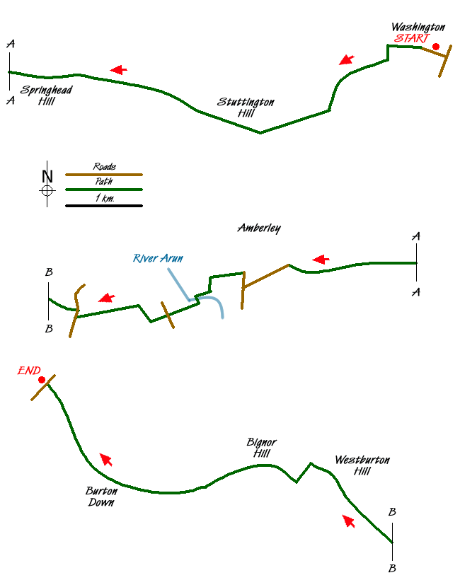
Situated in the Findon Valley, Washington is easily accessible from the A24. The walk starts at The Street (grid ref TQ120127) and heads west passing St Mary's Church to follow the SDW waymarkers with an acorn motif identifying this as one of the National Trails.
The early section is quite deceptive as it continues over fairly level ground on metalled roads and paths. Soon though, the track becomes a rougher flint surface and steepens as you get up onto the Downs. Turn left and head south past Home Farm Cottages veering southwest and then south again to rejoin the direct route of the SDW approximately 1 mile further along. Now out into the open and near the summit of Barnsfarm Hill (205m), the views get quite spectacular. Easily visible are the seaside resort of Worthing, the Weald, North Downs and behind you, Chanctonbury Hill.
The track continues westerly for the next four miles passing two car parks and various hilltops, including Sullington, Kithurst and Springhead Hills. The steep slope to the right side that you may have enjoyed on previous sections of the SDW is still there, but tantalisingly just out of sight for much the time. Views over the Weald are still there though - just wander off to the right to see them. Continue to reach the trig pillar on your left at the summit of Rackmans Hill (193m) and immediately start the long and mostly gentle descent into the Arun Valley.
There are some panoramic views here, with an occasional glimpse of the river below, over towards the Weald and ahead to the other side of the valley with Bignor Hill and the radio masts in the distance. Take it easy with your camera descending into the valley though. The scenery, as good as it is, gets even better looking back from the slopes on the far side.
Go through a gate and continue ahead onto the road to take the left fork (Go right if you are heading for Amberley) to reach the main road. (At this point you may turn left turn left for Amberley railway station.) Turn right and take the narrow path that runs parallel and slightly away from the road to reach the crossing point. Although large signs warn traffic that this is the SDW crossing for pedestrians, do take care.
Go over the railway bridge and past the treatment works to turn sharp left to reach the banks of the River Arun. Probably looking fairly gentle, but the raised banks and the wide flood plain offer some clues as to the river's occasional less benign nature. Tidal here and for a few more miles upstream, on its day this is apparently the second fastest flowing river in the country. Go left here along the banks if you want to stop for local refreshments at Houghton or to finish the walk. Alternatively go right to reach and cross the footbridge over the river to stay on the SDW. Built in 1993, the footbridge diverts the SDW away from the narrow and quite dangerous (for pedestrians) road bridge at Houghton that was the only option of crossing the river until then. The footbridge itself is now something of an icon for the SDW, images of it adorn the cover of at least one local guidebook.
Turn right for a short distance along the bank and then south easterly over the flood plain (here only 4m above sea level) to cross the minor road. Head out of the valley in a general west south westerly direction, with one dog leg to the right, to reach the main A 29 road. Go right along the verge for some 50m to cross. The way now veers northeast to reach the summit of Westburton Hill. This section offers some marvellous views back over the Arun Valley and you will also get an almost last look at the Sussex Weald as the path now takes a somewhat lower route to the south away from the high ground.
From here, the prominent Bignor Hill (225m) is the next point due west, but the Way first veers sharply to the left to then straighten to first reach the recently replaced Toby's Stone. This is a welcome resting place for travellers and a famous spot on the South Downs. Continue to pass through the parking area maintaining direction to stay on the SDW. Not shown on the waymarkers, but that path to the left at grid ref SU969128 is part of Stane Street (Roman Road) and The Monarchs Way, both famous historic routes in their own right.
The path now starts to veer to the right and passes Burton and Sutton Downs and maintains a North Westerly direction to dogleg left and then soon right at grid ref SU952142 on the descent to the A285 road next to Littleton Farm. All walks have to finish somewhere, and with a bus stop either side of the road and a little lay by here, this is as good a place as any. On the other side of the road, the way ahead rises up onto the Downs again, but that will have to wait for another day.
Notes - Tapped drinking water is available alongside the path just before you reach the footbridge over the River Arun. A handy website for planning the transport aspect of your trip is at www.visitsouthdowns.com
Messaging & Social Media
Message Walking Britain and follow the latest news.

Mountain Weather
Stay safe on the mountains with detailed weather forecasts - for iOS devices or for Android devices.