Walk 3339 - printer friendly version
Mynydd Anelog & the Whistling Sands Walk
Author - Lou Johnson
Length - 4.5 miles / 7.3 km
Ascent - 600 feet / 182 metres
Grade - easy
Start - OS grid reference SH166295
Lat 52.8317240 + Long -4.7238777
Postcode LL53 8LH (approx. location only)
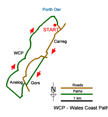
This Gwynedd walk explores a section of the north coast of the Lleyn Peninsula using quiet country lanes, footpaths and a section of the Wales Coast Path. Generally navigation is easy although some care is required near Mynydd Anelog where the assistance of a detailed map would be useful.
The start is the small car park (grid ref. SH166295) used for access to the fine beach at Whistling Sands. After parking walk south back towards the lane used for access to the car park and turn right. Continue along the lane past Carreg on your right. If you feel energetic then a short diversion to the top of Mynydd Carreg with its fine viewpoint is worth the extra time.
Continue along the lane to reach a T-junction (grid ref. SH162283) at Capel Carmel. Almost opposite and just to the left of the building facing you, follow the signed footpath across a number of fields. The path becomes a wider track, passes Gors on your right to reach a lane (grid ref. SH156273). Turn right along the lane and then take the track on your left. Just after the last house on your left the path enters open country.
Continue walking south towards a house surrounded by a wall. Keep the house and wall on your left and continue towards a gate in a wall (grid ref. SH154270). Do not go through the gate, instead turn right and follow the path alongside the wall (wall to your left). At the wall corner continue straight ahead to reach a wide grassy path. You can either continue straight ahead and follow the path across the summit of Mynydd Anelog or bear right onto a wide grassy path that crosses the eastern flank of this hill. Assuming you have opted to take the wide grassy path continue walking until you reach a wall corner just past some buildings (grid ref. SH150274).
You have now joined the Wales Coast Path. Turn north and follow the broad path/track through a gate. Reaching a junction, walk left and follow the sinuous track until the Wales Coast Path bears left off the track (grid ref. SH152280). Continue following the Wales Coast Path for about 1.5 miles. The path is generally easy to follow with the sea to your left. At Porthorion you cross a footbridge. Do not take the path down to the shore instead follow the path ahead that runs parallel to the wall along the cliff tops. Eventually you reach the southern end of the beach at Whistling Sands. Here you turn inland and the car park where you started is a short way along the track.
Messaging & Social Media
Message Walking Britain and follow the latest news.

Mountain Weather
Stay safe on the mountains with detailed weather forecasts - for iOS devices or for Android devices.