Walk 3345 - printer friendly version
Coombe Hill from Wendover Walk
Author - Lou Johnson
Length - 4.0 miles / 6.5 km
Ascent - 450 feet / 136 metres
Grade - easy
Start - OS grid reference SP865077
Lat 51.7613130 + Long -0.7480656
Postcode HP22 6BT (approx. location only)
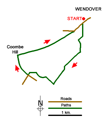
An easy Chiltern walk that rewards your efforts with some fine views across the Chiltern escarpment and across the Vale of Aylesbury. The paths and bridleways are generally clearly signed. If arriving by car, start from the car park in Wendover (grid ref SP868077). Exit the car park and turn left up the High Street and go straight on to pass Station Approach on the right and over the A413. If arriving by train (regular services from Marylebone), turn right out of the booking hall, go up Station Approach and at the main road turn right and cross over the railway and the A413.
Just after crossing the A413 take the first footpath on the left. Entering a field take the path heading half right which leads to a lane. Turn right up the lane and take the first signed path on the left between houses. Walk half right across the first field. Do not go over the stile, instead turn right through the gate (grid ref. SP865068). Follow this bridleway uphill for about 800 metres to reach a T-junction with a bridleway (grid ref. SP858059).
Turn right, soon crossing a private driveway. The path divides. Take the right hand path (a signed footpath) and after 150 metres turn left at a waymarked post into woodland. Continue until you reach a T-junction of paths with a waymark (grid ref. SP854060). Turn right here and walk for just over 200 metres to reach another footpath waymark (grid ref. SP853062). Turn left here and walk through the wood to exit at the National Trust carpark.
Continue straight ahead through a wooden gate and follow the left-hand path. The path begins to descend. At this point turn right onto the Ridgeway national trail. You soon arte able to enjoy some wonderful views to Chequers (below on your left) and the Vale of Aylesbury. Reaching the monument on Coombe Hill the panorama improves with Wendover Woods also coming into view.
Careful navigation is needed leaving the summit area of Coombe Hill. There is a very inviting clear gravel path, which leads back to the National Trust car park. Ignore this and take the waymarked Ridgeway across grass. This provides a gradual descent towards Wendover with a number of paths providing alternative routes over Bacombe Hill. Reaching the road (grid ref. SP863074), continue straight ahead descending past cottages and houses on your left to cross the A413. Turn left for the station or continue ahead to reach the car park, which is off to your right by the Library.
Messaging & Social Media
Message Walking Britain and follow the latest news.

Mountain Weather
Stay safe on the mountains with detailed weather forecasts - for iOS devices or for Android devices.