Walk 3371 - printer friendly version
Mynydd Cilan from Hell's Mouth Walk
Author - Lou Johnson
Length - 7.3 miles / 11.9 km
Ascent - 1000 feet / 303 metres
Grade - moderate
Start - OS grid reference SH284267
Lat 52.8104670 + Long -4.5474391
Postcode LL53 7LG (approx. location only)
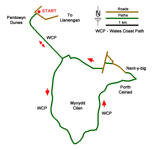
This Llŷn Peninsula walk explores the dramatic coastline around the headland of Mynydd Cilan, which lies west of Abersoch. The route starts from the extensive sands at Hell's Mouth and follows the Wales Coast path to reach the highest point of Mynydd Cilan. The walk continues along the coast to the beach at Porth Ceiriad where the route turns inland to return to the start. The walk crosses an area rich in wildlife with the cliffs providing breeding sites for a wide variety of sea birds.
The start is the small car park close to Pentowyn Dunes (grid ref. SH284267) which lies about a kilometre west of Llanengan. After parking take the path at the back of the car park down to the beach. Turn left along the top of the dunes (with the sea on your right) following the Wales Coast Path. Continue to the end of the beach to pass through a metal kissing gate. The path follows the fence on your right up a field to another kissing gate. The path gains height steadily to cross a wooden footbridge from where there is a good view back along Hell's Mouth Bay.
Still gaining height, the cliff top path provides increasingly better views. Another kissing gate underneath a crag is followed by another plank bridge. The next kissing gate provides a great view across the bay. Continue climbing with a waymark post on the skyline ahead. More way markers help with route finding. Reaching a path junction, turn right onto a broad grassy which gains more height although not so steep. Continue across the heathland to reach the OS trig point, which marks the highest point of the walk. Continue along the undulating waymarked path to reach the headland of Trwyn Cilan.
The path bears left here and continues across the heath to reach a gate. Turn right here at the fingerpost and descend to a kissing gate. Care is needed on the next section as the cliff edge is close by on the right. Ahead you can enjoy the view as you descend to a footbridge followed by steps and a gate. Another climb leads to a kissing gate and fingerpost on your right. Ignore this path and continue ahead as you make progress the beach at Porth Ceiriad comes into view. Stay on the coast path, which is waymarked and easy to follow. A steady descend leads to a small parking area (grid ref. SH311249). Cross the fence and follow the lane uphill away from the coast. Pass through the barrier and continue straight ahead to reach a row of houses on your left.
Just past the last house, go left onto the signed footpath (grid ref. SH306253). The path is clear and passes between buildings to a lane. Turn left uphill for 150 metres and turn right onto the signed footpath. Ahead you can see the sea at Hell's Mouth. Pass a house on the right and where the main track bends left, continue ahead and as you approach Bachwared Farm bear right onto a path keeping the house to your left. Pass through the kissing gate and head straight soon reaching a gate which leads into a field. Drop down the field keeping the fence on your left. Look out for a gap in the fence on the left with a coast path waymark. Turn left here and continue down a small valley over a footbridge. Cross the stile on the right and retrace your steps back along the beach to the start.
Messaging & Social Media
Message Walking Britain and follow the latest news.

Mountain Weather
Stay safe on the mountains with detailed weather forecasts - for iOS devices or for Android devices.