Walk 3373 - printer friendly version
Foryd Bay Walk
Author - Lou Johnson
Length - 5.6 miles / 9.1 km
Ascent - 100 feet / 30 metres
Grade - easy
Start - OS grid reference SH436566
Lat 53.0836480 + Long -4.3365677
Postcode LL54 5TW (approx. location only)
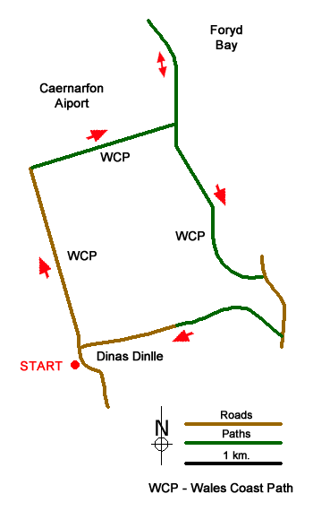
This Gwynedd coastal walk from Dinas Dinlle combines a visit to an Iron Age Fort, a section of the Wales Coast Path and views across the Foryd Bay to the high mountains of Snowdonia (Eryri). The route is easy to follow and involves little ascent.
The start is the small car park (grid ref. SH436566) in Dinas Dinlle adjacent to the Hill Fort. This is worth the short climb to enjoy the view. After visiting the fort, walk north along the seawall with the sea to your left. If tides permit you can walk along the sand. In fine weather you can see Anglesey with Llanddwyn Island jutting out to sea. Continue along the path or beach which runs parallel to the road on your right. Continue for two kilometres to reach a car park (grid ref. SH432583). Go through the car park to the road and then follow the road with the green perimeter fence to Caernarfon Airport on your right.
You are still following the Wales Coast Path as you head along the road, which eventually becomes a track. Reaching a T-junction of paths with a three-way fingerpost (grid ref. SH444587), turn left and continue along the clear gassy path for about 1.5 kilometres to skirt Foryd Bay Nature Reserve which is rich in wildlife and birds. Across the bay there is a fine view to the mountains of Snowdonia. After enjoying the solitude return to the three-way fingerpost and continue straight ahead on a grassy with salt marshes to your left.
After 800 metres of easy walking you reach a wooden footbridge across the Afon Carrog. The Wales Coast Path crosses the bridge, but we follow the grassy path along the riverbank. The path strays from the river and you continue to a gate by a stone bridge. Continue ahead keeping the river on your left. When the river bends to the left continue ahead for a few metres and head slightly right towards a house and barn. Cross a footbridge, bear left past the barn and right around the house. To cross the field to far left-hand corner to exit the field by a footpath sign and a metal kissing gate (grid ref. SH452575).
Turn right along the lane and continue past a row of cottages. The road curves round to the right and shortly after there is a footpath sign on the right. Turn down the access drive to Fferm Cefn Emrys. Continue to reach the farm where you head straight through the farmyard to follow a path between hedges. Just after the track turns sharp right you cross a steam with an adjacent footbridge. Continue between hedges soon joining a tarmac lane. Follow this past a caravan site on the right to reach the road along the coast. Turn left and the car park used at the start of the walk is a short distance along this road on the right.
Messaging & Social Media
Message Walking Britain and follow the latest news.

Mountain Weather
Stay safe on the mountains with detailed weather forecasts - for iOS devices or for Android devices.