Walk 3378 - printer friendly version
Gyrn Goch, Gyrn Ddu & Bwlch Mawr Walk
Author - Lou Johnson
Length - 6.5 miles / 10.6 km
Ascent - 2200 feet / 667 metres
Grade - mod/hard
Start - OS grid reference SH405487
Lat 53.0117780 + Long -4.3788962
Postcode LL54 5PH (approx. location only)
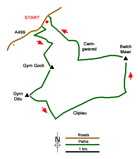
This Llŷn Peninsula walk visits three summits lying to the east of Yr Eifl. The route involves a steep climb onto Gyrn Goch, from where the walk is less demanding. Once high ground has been reached there are superb views including west to Yr Eifl and the coast, south across the peninsula and east to the summits of the Nantlle Ridge and beyond to the Snowdon massif. Route finding is generally good although you need a 1;25k OS map and a sense of direction.
The start is the lay-by on the south side of the A499 at Pont y Felin (grid ref. SH405487) about a kilometre south of the village of Clynnog Fawr. After parking take the signed footpath through a gate on the east side of the river. After 180 metres the path swings right across the Afon Hen and then trends half right through trees to reach open country. Continue ahead along a grassy track to the first wall where you turn sharp left to follow a clearer path which passes to the left a walled enclosure with woodland on your left. The path then veers right away from the wall and continues to reach a cross wall (grid ref. SH408482).
Turn right and follow the path beside the wall. Climb steeply, gaining about 900 feet, keeping with the wall as it heads right to reach the summit of Gyrn Goch (492 m.). Take a break and enjoy the view, also familiarise yourself with the lie of the land. The onward route follows the continuing wall (wall on your right) to drop to a col before climbing up to the rock-strewn summit of Gyrn Ddu (522 m.) which is the highest point of the walk.
Descend through the rocks trending eastwards to the 491-metre spot height on OS maps. Bear to the right of this minor summit, cross the wall and turn right to descend past a ruined enclosure on your right and follow the wall on your right down to a clear path with a wall just beyond (grid ref. SH409462). Turn left and follow the path with the wall on your right. When the wall ends keep head to join an enclosed track which soon leads into open country. There are several paths with the best option being to initially shadow the wall on the right. The path veers away from the wall and head to a gate (grid ref. SH425468). Go through this gate and head uphill keeping the rocky area to your left. Cross the wall and continue ahead to the summit of Bwlch Mawr (509 m.). The view from here to Snowdonia (Eryri) is superb with the nearest mountains being the Nantlle Ridge.
Leave the summit on the path heading west and running parallel to the wall on your left. Cross the wall ahead and start the steep descent aiming for the left-hand end of the plantation below. Choose the best line avoiding the rocky areas which are best passed on their left. Reaching the boundary of the plantation (grid ref. SH415478), keep the wall on your right and drop down to the stream. Cross the broken wall to enter the plantation. Head half right to join a path which leads from the waterfall. Follow this path through the trees to join a track. Bear right along the track and follow it past Cwmgwared farm back to the A499. Turn left and the starting point is a short distance along the road on your left.
Messaging & Social Media
Message Walking Britain and follow the latest news.

Mountain Weather
Stay safe on the mountains with detailed weather forecasts - for iOS devices or for Android devices.