Walk 3420 - printer friendly version
Cookham to Gerrards Cross via Burnham Beeches Walk
Author - Peter Smyly
Length - 12.5 miles / 20.3 km
Ascent - 350 feet / 106 metres
Grade - moderate
Start - OS grid reference SU886850
Lat 51.556936 + Long -0.723392
Postcode SL6 9HS (approx. location only)
This is a good choice of walk for a bright, sunny, autumnal day and, while the ancient woodland of Burnham Beeches may be the main draw, the different autumnal hues are frequently apparent during much of the walk as a whole with Littleworth Common, Dorney Wood, Brockhurst Wood and Stoke Common also included.
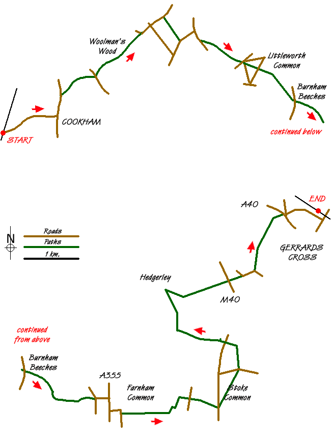
The Beeches Way is a linear route that extends for sixteen miles starting at the Berkshire village of Cookham in the west and ending at West Drayton in Buckinghamshire to the south east. This route follows the first few miles of the trail as far as Stoke Common before continuing along public footpaths for the most part to complete the route. The start point is Cookham railway station and Gerrards Cross railway station is the finish point. The route crosses several roads where care is needed in crossing. There are also a number of wooden stiles to cross. Gradients are mostly on the level with just the occasional gentle slope to walk up or down.
From Cookham railway station, follow the main road to the east, Station Hill, leading down to the main High Street and turn left into Ferry Lane which crosses a bridge over the River Thames. The Beeches Way is signposted to the right shortly after the bridge and a path crosses a field with a river on the right before it crosses first a stream then a road. The road leads to a kissing gate on the left and a path leading uphill through Woolman's Wood, a rare uphill stretch on this walk. Views are restricted by trees to a large extent until the path emerges into the open as the route passes Hedsor Farm, by which time the gradient has levelled out again. There is now a roadside walk for a few hundred yards, going straight across at the crossroads, before the route reverts to type with a path that heads off through woodland again, to the right. Following the signs for the Beeches Way, a mixture of paths and country lanes brings you to Littleworth Common and, just beyond it is a pub, the Blackwood Arms which has a large garden at the back, backing on to a field with woodland beyond.
The trail continues to the right of the pub and the ancient woodland of Burnham Beeches is reached next via Dorney Wood. One option, rather than following a direct route through the woods, is to do a circular route, enabling more of the ancient woodland to be seen. Walk along Victoria Drive towards Pumpkin Hill before a path turns uphill to the left and circles round to a car park at one of the main entry/exit points for Burnham Beeches to the east. A road from here takes you downhill to the east, away from the woods. Next the route goes to Farnham Common and then continues in the form of a narrow footpath off Parsonage Lane leading to. Brockhurst Wood which has a slight climb up a hill through the trees before the path turns left to border a field with horses on the right. As the footpath signs for the Beeches Way indicate, turn right to follow the edge of a field and cross the next road to continue up the other side, leading to Stoke Common, a Site of Special Scientific Interest (SSSI), due to the rarity of its heathland habitat.
Heading north, cross Stoke Common Road and follow the route north past Pickeridge Farm. Follow public footpaths leading to Hanging Wood via Hedgerley Park Farm, passing a field with bulls on the right. After descending through woodland, the path emerges into the open across a field before turning sharp right with Church Wood now on the left. The path ahead now leads across more fields to cross under the motorway ahead, seen and heard in the distance, via a subway. A wooden stile leads to Hedgerley Lane and, at the houses called Ponders, pass through Bulstrode Park in a roughly north east direction with woodland to the right. At the exit of the field, a road leads up to the right into Gerrards Cross and from here, the railway station is just a few minutes walk away, one option being to walk there via the common.
Messaging & Social Media
Message Walking Britain and follow the latest news.

Mountain Weather
Stay safe on the mountains with detailed weather forecasts - for iOS devices or for Android devices.