Yorkshire Three Peaks from Horton-in-Ribblesdale Walk
Walk 3433 - Route Maps & Profile
Route Map
Digital Maps - Copyright © 2011-2024. All rights reserved.
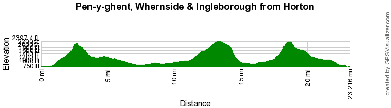
Route Profile
Sketch Map
Suggested Maps 

| Ordnance Survey Explorer OL2 | Sheet Map | 1:25k | BUY |
| Anquet OS Explorer OL2 | Digital Map | 1:25k | BUY |
It is recommended you take a map. The preferred scale is 1:25k.
Start Point Details
Ordnance Survey Grid Ref SD807726
Latitude 54.148858 Longitude -2.296977
Postcode BD24 0HF
what3words start struck.cookies.swooning
Walk description may contain detailed information on the start point for this walk.
Further Information
Yorkshire Dales
Walking in the Yorkshire Dales National Park covers an extensive area, which contains a wide variety of scenic interest. Each Dale is usually named after its river although there are a few examples that don't follow this rule. The varied underlying geology is reflected in the scenery with limestone and gritstone the prominent rocks resulting in virtually every type of scenery from dry valleys to wild moorland. Yorkshire Dales Walking Guide
North Yorkshire
North Yorkshire is a large county and contains some of the finest walking in Britain. The Yorkshire Dales and North York Moors National Parks offer varied routes to suit all abilities with wonderful scenery. Outside of the two National Parks, there are many walks offering rural tranquillity and pleasant walking. The Pennine Way, Dales Way and Coast to Coast long distance paths offer excellent circular walks exploring the landscapes of this historic county.
Walk grading - Learn how each walk is assessed and select a walk to suit your ability and experience by going to Walk Grading Details.
Messaging & Social Media
Message Walking Britain and follow the latest news.

Mountain Weather
Stay safe on the mountains with detailed weather forecasts - for iOS devices or for Android devices.