Whitbarrow Scar from Mill Side Walk
Walk 3549 - Route Maps & Profile
Route Map
Digital Maps - Copyright © 2011-2024. All rights reserved.
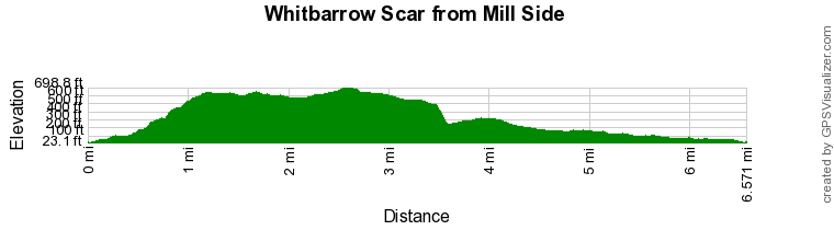
Route Profile
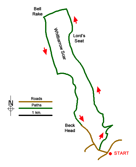
Sketch Map
Suggested Maps 

| Ordnance Survey Explorer OL7 | Sheet Map | 1:25k | BUY |
| Anquet OS Explorer OL7 | Digital Map | 1:25k | BUY |
| Ordnance Survey Landranger 97 | Sheet Map | 1:50k | BUY |
| Anquet OS Landranger 97 | Digital Map | 1:50k | BUY |
It is recommended you take a map. The preferred scale is 1:25k.
Start Point Details
Ordnance Survey Grid Ref SD452839
Latitude 54.247836 Longitude -2.842497
Postcode LA11 6SQ
what3words start deflated.congratulations.edgy
Walk description may contain detailed information on the start point for this walk.
Further Information
Lake District
Walking in the Lake District National Park is amongst the best in the British Isles. The natural beauty has attracted many artists and writers through the centuries and today the same scenery provides the perfect backdrop to a wide variety of walks. The National Park is located wholly within Cumbria with Windermere, Ambleside and Keswick the main tourist towns. For many this is the finest area in England for walking with a wide variety of scenery. Even on the busiest weekends it is possible to get away from the crowds by carefully selecting one of the less-visited fells. Lake District Walking Guide
Cumbria
Cumbria is one of the finest places for walking in Britain with rugged peaks, rolling hills, lakes and valleys providing a wonderful variety of landscapes. Cumbria includes the Lake District National Park, the Howgill Fells, part of the Yorkshire Dales National Park and the highest peaks of the North Pennines so who could ask for more? Sections of the Coast to Coast, Dales Way and Pennine Way long distance paths can also be explored.
Walk grading - Learn how each walk is assessed and select a walk to suit your ability and experience by going to Walk Grading Details.
Messaging & Social Media
Message Walking Britain and follow the latest news.

Mountain Weather
Stay safe on the mountains with detailed weather forecasts - for iOS devices or for Android devices.