Walk 3570 - printer friendly version
River Tone from Stoke St Gregory Walk
Author - Lou Johnson
Length - 5.2 miles / 8.5 km
Ascent - 250 feet / 76 metres
Grade - easy
Start - OS grid reference ST347272
Lat 51.0404280 + Long -2.9327690
Postcode TA3 6HA (approx. location only)
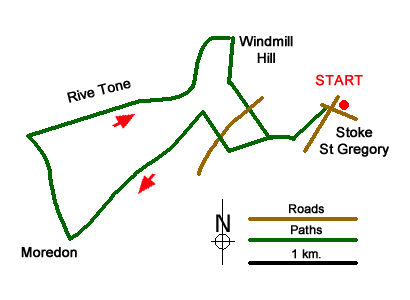
This Somerset walk starts from the village of Stoke St Gregory which lies to the east of Taunton on low ridge of higher land. Surrounded by low lying flood plains to the south and north. After wet weather, especially in winter, this walk may be impassable. There is some on-street parking in the village near the Village Store (grid ref. ST347272). However please park considerately.
After parking and with your back to the village store, turn left. Bear right at the first road junction into Willey Road. Walk past the school on your left and immediately after take the signed footpath on the left through a metal gate. Continue straight ahead crossing Huntham Close. Reaching a path junction just after the houses on the right, continue straight ahead. The path soon turns sharp right and continues to a footbridge (grid ref. ST343270). Turn left across the bridge and follow the path (hedge on your right). Ignore the stile on the right and continue ahead to the end of the field.
Turn right and with the hedge on your left continue to a road (grid ref. ST337269). Turn right and then left to follow the continuing path through the Wetland Centre. After 250 metres by a clump of trees, turn left onto the East Deane Way. Go straight across the first field, continues across the next (hedge right). The path then goes sharp right and almost immediately sharp left along the edge of a field with the hedge on your right. Part way down the filed the path passes through the hedge before continuing in the same direction with the hedge now on your left. Continue to the end of this large field.
The onward path enters another field (with the hedge on your right) to reach a track with hedges either side (grid ref. ST330265). Cross the track into a large field and head at eleven o'clock to the field corner. The continuing path alongside a hedge (on your right) to join a rough track which leads to Mordon Lane just past a solitary house on your right. Turn right along Mordon Lane. Where the main track bends to the left continue ahead through trees. Continue down the farm track as it descends to the flood plain. (grid ref. ST324263). After 500 metres, where the track turns sharp left, continue ahead into the field aiming for the far-left hand corner.
You now join the path alongside the River Tone. Turn right with the river to your left and follow this pleasant path for just over two kilometres to reach Hook Bridge, which is the first bridge after joining the riverside path. Now following a good farm track, turn right on the waymarked path on your right just before reaching the farm buildings. Follow the path with the farm buildings on your right and climb steeply up onto Windmill Hill. Continue straight ahead (hedge left) and descend to reach a small water treatment plant> Turn left along the access road and walk to a lane (grid ref. ST340272).
Turn right along the lane. Very shortly, turn left onto a signed footpath that leads in front of a terrace of cottages. Continue through a field with hedge right. At the end of this field, cross the stile and turn right. You are now back on the outward route soon crossing a footbridge. Retrace your steps back to the start.
Messaging & Social Media
Message Walking Britain and follow the latest news.

Mountain Weather
Stay safe on the mountains with detailed weather forecasts - for iOS devices or for Android devices.