Walk 3572 - printer friendly version
Lambourn Valley & Great Shefford Walk
Author - Lou Johnson
Length - 9.0 miles / 14.6 km
Ascent - 600 feet / 182 metres
Grade - easy/mod
Start - OS grid reference SU382753
Lat 51.4753780 + Long -1.4513705
Postcode RG17 7EJ (approx. location only)
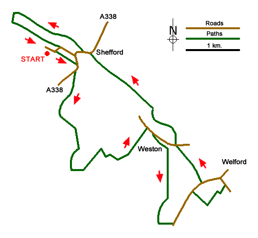
This Berkshire walk starts from the village of Great Shefford in the Lambourn Valley. The route explores typical English countryside and includes the village of Weston and nearby Welford Park. The route can be reduced in length at two points in the walk (see text for details). On street parking can be found on Church Street (grid ref. SU382753) although please park with consideration.
To start the walk head west along Church Street away the main road. Church Street bends to the left, goes uphill. Reaching a driveway on the left leading to a large barn, take the steps on the left. Follow this path as it runs behind gardens on your immediate left. Continue along the path to reach the A338. Turn right past the malt house. After 50 metres go through metal gate on the left and follow the track. After a kilometre turn left at a signpost (grid ref. SU381741). Walk past an area of trees on your left and at the end of the trees go half right across the field.to join a track. Bear right along the track. Continue for 400 metres and then turn left onto the driveway for Oakhanger Park.
Continue past the house (on your right) and then turn left on a signed footpath. Continue to the end of the trees on your left (grid ref. SU388735) where you turn right along a track. This track turns left and the right with trees on your left. Just after the last tree take the footpath on the left and go half right across the field. Follow the clear path with hedge on your right to reach Newbury Road after 650 metres.
Turn right along the road. Continue for just over 100 metres and take the stile on the right (grid ref. SU397738). The path leads behind houses on your left to reach a field just beyond Weston Farm. The path then goes half right across a field. Maintain the same direction across the next field to a gate (grid ref. SU400727). Go through the gate and follow the way-marked path to reach the M4 Motorway. Turn left along a track parallel to the motorway and continue to Welford Road (grid ref. SU401723). Turn left and continue to just before a War Memorial (grid ref. SU404728).
The main route turns right here into the woods. (To shorten the route continue along the road to reach point B in the text below). The path leads into an open field. Follow path across the field to reach a track after 200 metres. Turn left and follow the track to a lane near Home Farm. Turn left along the lane passing a thatched cottage on the left to a T-junction with St Cuthbert's Church opposite. Turn left here onto Welford Road. After 250 metres turn right through a kissing gate, adjacent to a gravel access track to Welford Park. Point B - for those taking the shorter route continue along Welford Road for 300 metres on the take the path through the kissing gate on the left (grid ref. SU406730).
The path skirts to the right of Welford cricket ground and leads to the corner of the field. The onward path continues through a gate and continues through two fields to reach Newbury Road by a house (grid ref. SU401737). Go straight across the road and follow the path to the right of a large house. Continue along the path over a footbridge. After crossing a second footbridge turn left through a gate. Continue along the path with the River Lambourn to your immediate left to a lane.
Turn right and pass through farmyard following the Lambourn Valley Way which follows a former railway line. After 1.6 kilometres you reach the A338. You can further shorten the walk at this point. Turn left along the A338 and continue over the river bridge. Church Street is the first road on the right after the bridge. For those completing the full walk, turn left along the A338. Turn right into Station Road and follow it round to the right and then left. The onward path leads off Station Road and soon follows a field boundary on your left. This path leads to Maidencourt Farm where the path follows the infant River Lambourn on your immediate left.
Turn left up the tree lined farm drive. After 150 metres from the river, turn left onto the signed footpath. The path is easy to follow with the River Lambourn on your left. You soon pass St Mary's Church on your right. Reaching a driveway, turn right to regain Church Street. Continue ahead into the village centre and the A338.
Messaging & Social Media
Message Walking Britain and follow the latest news.

Mountain Weather
Stay safe on the mountains with detailed weather forecasts - for iOS devices or for Android devices.