Walk 3580 - printer friendly version
Carmel Head & the Skerries from near Cemlyn Bay Walk
Author - Lou Johnson
Length - 4.5 miles / 7.3 km
Ascent - 620 feet / 188 metres
Grade - easy
Start - OS grid reference SH317926
Lat 53.403311 + Long -4.5330899
Postcode LL67 0DY (approx. location only)
The north coast of Anglesey has some dramatic cliffs and coastal waters making it an attractive place for surfers, sea kayakers and climbers. The Anglesey Coast Path, which is followed for part of this route, adds walking to this list of activities. Finally in season it is home to many species of sea birds and this annual breeding attracts many ornithologists to the area. Off shore you can see the Skerries Lighthouse, which is built on the Skerries, a series of small rocky islands, just off the coast.
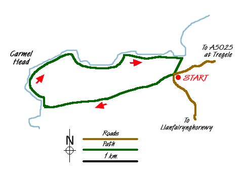
The start is a small car park (Grid ref. SH317926). The easiest route is to leave the main A5025 at Tregele (just west of Cemaes) and follow the signs for Cemlyn Bay but continuing straight ahead to reach the start. After parking follow the signed footpath west passing Mynachdy on your right. More of a track than a path, keep straight ahead maintaining a westerly direction to reach a point where the track veers right (Grid ref. SH303921). Keeping the small lake on your right continue on a less clear track that descends into a shallow valley. The track becomes a path and this leads you to the coastal footpath (Grid ref. SH292291).
Turn right along the coastal footpath enjoying the wild coast and looking out to the Skerries. This was a treacherous coast and the addition of a lighthouse and a light on West Mouse is ample evidence of the need for navigational aids in this area. Continuing around Carmel Head you reach the remains of mining activity and more evidence of maritime navigational aids in two large daymarks, or landmarks, made from concrete. Unlike marks on other sections of coast which seem to have been painted to assist visibility these marks remain unpainted. As the path swings east, the height of the cliffs drops and for the next section you are always quite close to the sea.
At the small cove of Hen Borth (Grid ref SH318928), leave the coastal path and turn right on the signed footpath across fields back to the start. It is possible to extend this walk by continuing on the coastal footpath as far as Cemlyn Bay and then walking back along the lane, which at the time of this research was very quiet.
Messaging & Social Media
Message Walking Britain and follow the latest news.

Mountain Weather
Stay safe on the mountains with detailed weather forecasts - for iOS devices or for Android devices.