Walk 3597 - printer friendly version
Manifold Valley, Thor's Cave, Ecton & Wetton Hills from Alstonefield Walk
Author - Daryl Smith
Length - 10.0 miles / 16.3 km
Ascent - 1350 feet / 409 metres
Grade - moderate
Start - OS grid reference SK130556
Lat 53.0974470 + Long -1.8073102
Postcode DE6 2FY (approx. location only)
A superb Peak District walk combining interesting locations with stunning countryside and superb views and with the added bonus of starting from the delightful Staffordshire village of Alstonefield. This area is the White Peak at its best, a "magical valley" with "some of the most dazzling landscape in the British Isles" in the words of that great champion of the countryside, the late Candida Lycett Green in her 2009 book Unwrecked England.
Our walk is based on the lovely village of Alstonefield high in the Staffordshire White Peak. There are three free car parks in the village, one with toilet facilities and the village is of course home to the renowned "George at Alstonefield". On the route of the walk there are public toilets and a pub at Wetton and a cafe at Wetton Mill (seasonal opening times).
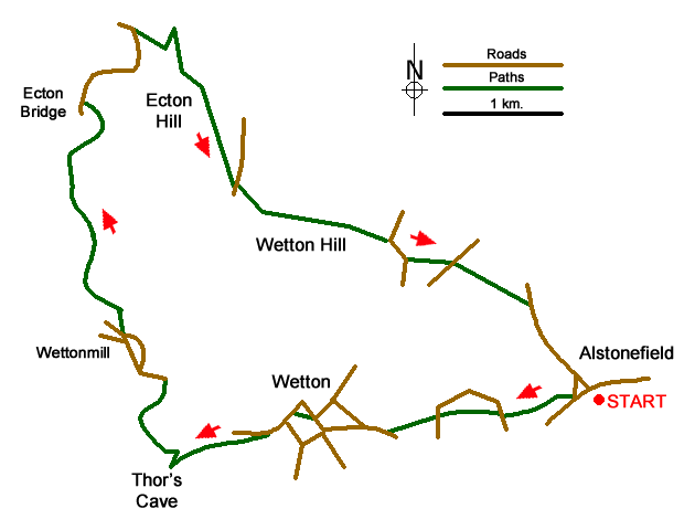
From the green in front of the George head out west and take the track at the side of the village hall, this leads to a footpath across sports fields and out onto the hillside. Follow this path through Hope Marsh straight across two lanes and up towards Wetton. Where the path emerges onto a lane on the outskirts of Wetton take the first lane on the right and then turn left along the Mires.
Go up to the centre of the village opposite the Royal Oak and walk through the churchyard. If the church is open, pop in to see examples of old and strange "footprint graffiti" taken from the roof! Again, head out west and just as you leave the village follow a concessionary path on your left signposted for Thor's Cave (NB do not take the adjacent public footpath). After exploring the cave follow steps down to the valley floor, turn right on the surfaced track, this is a walkway and cycleway built on the track bed of a former narrow-gauge railway closed in 1934. Where the track crosses the lane take the left fork following the old road. On the way to Wetton Mill, you will come to Dafar Bridge at the downstream end of a stretch of the Manifold where it often disappears underground. For much of the year the river flows four miles underground from "swallet holes" below Wetton Mill before emerging from "boil holes" in Ilam Park. If you don't want to walk through the ford at Wetton Mill, there is a footbridge sometimes hidden by vegetation over to your left.
Our preferred route to Swainsley follows a gated road on the opposite side of the river; cross the bridge passing the cafe entrance and turn left in front of Dale Farm. Towards the end of the gated road you will see Swainsley Hall through the trees, a former owner was one of the principal promoters of the ill-fated railway and the track went into tunnel behind the Hall so as not to disturb his enjoyment of the valley. There is a disused mine entry at the side of the road, you will soon see many more.
At the end of the gated road turn right on the lane following the river valley around the foot of Ecton Hill. You will see the old engine house on top of Ecton Mine up above you on the hillside and pass by remains of structures where mineral processing took place. Ecton Mine was in its day the most productive copper mine in the country, innovative engineering was used, and it made a fortune for the Dukes of Devonshire. If you drop down behind the ruins on your left you can see the mouth of Ecton Deep Adit, this was where water pumped from the lower mine workings was discharged to the river. The height of the engine house above the river is less than one quarter of the total depth of the mine! Rich in ores of copper with some lead and zinc, Ecton Hill was mined extensively until the productive deposits were exhausted; in addition to Ecton Mine there were many smaller enterprises.
Our onward route takes the sharp right turn up a track behind the former mine manager's house, but it is worth continuing around the bend as far as Apes Tor to see the rock formations contorted by unimaginable forces when continents collided. The (sealed) shaft at Apes Tor gave access to an underground canal used in mining operations.
Returning to the track go up as far as a path in front of a most unusual house, turn left but then keep right to follow a permissive path that loops round the hillside up to the engine house that you saw from below. Take time to explore and you can stand on the shaft cap with the lowest level of the mine over 400 metres below your feet.
Continue straight up the hillside past abandoned mine entries, go through a gate and veer right to the trig point at the top of Ecton Hill. Looking north you can see the landscape change where the White Peak meets the Dark Peak. Head off in a southerly direction, the permissive path is unmarked but meets a right-of-way at the side of a ruined mine building. You may see White Park Cattle in the fields at Broad Ecton Farm, a very distinctive and extremely rare breed. Continue straight ahead to a lane at Back of Ecton, drop down to a junction and turn right; at a sharp right-hand bend leave the lane onto the foot of Wetton Hill. Go around the northern side of Wetton Hill, gradually gaining height, you are in access land so you can "bag" another top on the way if you wish.
At the eastern side of Wetton Hill, don't go through the tempting open gateway but over a stile and across a field to a lane. Turn right on the lane then left on a path past the side of Gateham Farm; follow the left-hand path at the sign-posted path junction by the farm and continue across a lane and several fields followed by a pleasant stroll down the Raikes into Alstonefield.
Alstonefield church is also worth a visit; you will find the oldest known legible gravestone in the country (Ann Field d.1518), a strange family pew and an ancient jokey version of a pagan Sheela-na-gig, remaining defiant even whilst being consumed by a demon!
Footnote: Ecton Mine is now owned by an educational trust and used for study purposes but the National Trust arranges a seasonal programme of underground visits, these fascinating visits are on one level with no climbing or descending of mine shafts involved.
Messaging & Social Media
Message Walking Britain and follow the latest news.

Mountain Weather
Stay safe on the mountains with detailed weather forecasts - for iOS devices or for Android devices.