Walk 3614 - printer friendly version
Herrock Hill from Kington Walk
Author - Lou Johnson
Length - 8.0 miles / 13 km
Ascent - 1400 feet / 424 metres
Grade - moderate
Start - OS grid reference SO291567
Lat 52.203947 + Long -3.0388898
Postcode HR5 3AQ (approx. location only)
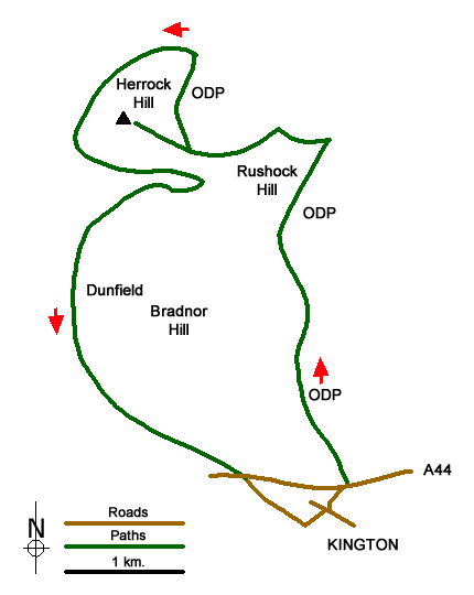
This Herefordshire walk starts from Kington and explores the hilly landscape to the north of this market town. The outward route follows the Offa's Dyke Path around the eastern flank of Bradnor Hill to reach the foot of Herrock Hill. After ascending this fine hill, the route continues north before leaving the Offa's Dyke Path to turn south along the western flanks of Herrock and Bradnor Hills back to the start.
The start is the Parish Church of St Mary (grid ref. SO290567) where limited parking is available on the lane off Montfort Road to the immediate west of the churchyard. After parking walk through the churchyard and exit onto Church Road. Walk into the town centre. The road bends to the right and heads downhill. Turn left into Doctors Lane and follow it to reach The Square (on your right). Continue straight ahead still on Doctors Lane and follow the road to the left. At the next crossroads go straight across into Crooked Well. Continue to the end of the road, climb the steps and cross the A44.
Follow the fingerpost "Offa's Dyke Path" climbing up the access drive to a farm (Rhue Ville). Walk past the front of the house to join the onward path which is beside the right-hand end of the house. The path climbs steadily to the houses at Bradnor Green (grid ref. SO291576). Here you cross a track and bear towards the right-hand end of a cottage. Maintain a northerly direction across the golf course to reach a clear track (grid ref. SO291579).
Join the access drive to Quarry House. Almost immediately bear left onto the ODP. The path enters a filed with a small wood over on your right. At the northern end of the wood, the path veers left to reach open access land (grid ref. SO289588). The path heads NNE for 800 metres to reach a track (grid ref. SO293595). Turn left and follow the waymarked ODP. The path rises, turns sharp left, and then descends to pass a plantation on your right. Ahead lies Herrock Hill with a clear path leading to the summit.
Allow some time to enjoy the view before returning downhill to the ODP. Turn left and drop steeply down across the eastern flank of Herrock Hill to reach Herrock Cottage. The ODP swings left down to a gate. Just before gate fork left. Follow this path for 1.5 kilometres to enter a valley and leave open access land near Holywell (grid ref. SO283592). The path crosses a stile and turns right and crosses a pasture to another stile. Turn right and head down the valley having turned through 180 degrees to follow a track. Continue through three gates and just before Dunfield Farm, fork left, cross a stream and follow the waymark to a stile. Continue for 50 metres, turn right along the fence to a stile and shortly after a gate.
Cross an open area to enter a plantation (grid ref. SO274582). Go through the gate and take the narrow path. Fork right and keep ahead. Pass a pair of cottages on the right below the trees. Continue along an improving path to reach a lane by Dingle Cottage (grid ref. SO280574). Cross the lane and take the path opposite. The path contours across the hillside to the next cottage on your left. Here the path leads down to a track. Continue down the track for 150 metres and take the stile on the left. The path then takes a diagonal route across the hillside to a stile alongside the A44. Cross the road and join Montfort Road to walk back to the start.
Messaging & Social Media
Message Walking Britain and follow the latest news.

Mountain Weather
Stay safe on the mountains with detailed weather forecasts - for iOS devices or for Android devices.