Walk 3616 - printer friendly version
Fan Fawr from Storey Arms Walk
Author - Lou Johnson
Length - 6.0 miles / 9.8 km
Ascent - 1800 feet / 545 metres
Grade - moderate
Start - OS grid reference SN982203
Lat 51.8719510 + Long -3.4800584
Postcode LD3 8NL (approx. location only)
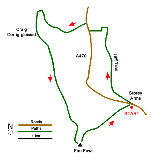
This Brecon Beacons walk visits the summit of Fan Fawr from Storey Arms on the A470 south of Brecon. The route initially follows a section of the Taff Trail before heading west to begin the climb to Fan Fawr. The route continues south along the crags of Craig Cerrig-gleisiad before heading cross country to Fan Fawr's summit from where an excellent view across to Pen y Fan can be enjoyed.
The start is the car park opposite the Storey Arms Outdoor Education Centre (grid ref. SN982203). Note that at weekends and in periods of fine weather spaces in the car park may be at a premium. After parking cross the road to the telephone box. Do not go through the gate but turn left onto the Taff Trail. Continue for just over two kilometres losing height gradually. Reaching a fingerpost on the left (grid ref. SN976222) descend on the Taff Trail to cross a stream. Where the Taff Trail turns right, go straight ahead uphill to a stile and layby on the A470.
Turn right and cross the A470 (with care) to a layby on the west side of the road (grid ref. SN971223). If the car park at Storey Arms is busy, then this a convenient alternative place to start. Go through the gate and climb beside the stream. As you gain height waymarks help with navigation with the path initially trending WNW. The path veers north alongside a fence. Where the fence goes left, follow the path uphill to reach a junction of paths (grid ref. SN959226).
Turn left along the main path following the fence. The path follows the edge of the crags Craig Cerrig-gleisiad. After 500 metres you reach a fence junction (grid ref. SN960221). Continue ahead along the top of the crags. Where the fence bends to the left after 400 metres you reach a path junction (grid ref. SN962217). Here you leave the edge path and continue straight ahead. Continue for just over two kilometres across open country. Where the path bends left (grid ref. SN969198) head south uphill. The feint path soon fades. The best approach is to veer right up the slope aiming for a large stone outcrop below the horizon after which you soon gain the ridge. Continue to the cairn (grid ref. SN969193).
You can now enjoy the view across the valley to the highest peaks in the Brecon Beacons with the car park feet below. Follow the clear path heading north along the edge dropping down steeply to the valley below. In places the path is hard to follow but a useful guide is the left-hand edge of the plantation at Storey Arms. Continue back to the start.
Messaging & Social Media
Message Walking Britain and follow the latest news.

Mountain Weather
Stay safe on the mountains with detailed weather forecasts - for iOS devices or for Android devices.