Walk 3619 - printer friendly version
Ribchester Circular Walk
Author - Lou Johnson
Length - 7.0 miles / 11.4 km
Ascent - 700 feet / 212 metres
Grade - easy/mod
Start - OS grid reference SD649352
Lat 53.8118930 + Long -2.5345408
Postcode PR3 3YS (approx. location only)
This Lancashire starts from Ribchester and dates from the Roman occupation. Lying on the northern bank of the River Ribble with the hills of the Forest of Bowland to the north, the village provides an excellent base to explore the surrounding countryside. This route heads north following paths and lanes to reach a grand viewpoint across the Ribble Valley. The return route heads south through pleasant landscapes. At the end of the walk allow time to visit the Roman Baths and Museum in Ribchester.
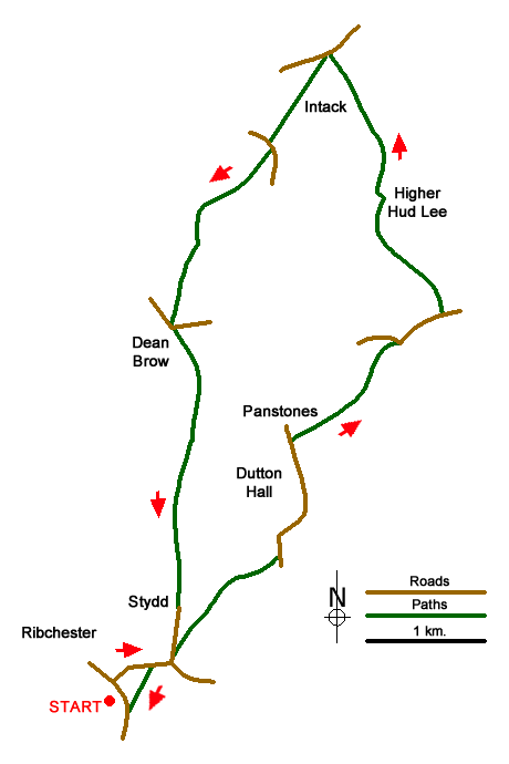
Church Street carpark (grid ref. SD649352) is a convenient place to start, which is close to the village centre. Exit the carpark onto Church Street. Turn left and continue to the Black Bull pub on your right. Turn right here and follow the B6245. The road bears to the right to a crossroads. Go straight across following Blackburn Road out of the village. Just before a stone bridge, turn left into Stydd Lane and cross a smaller stone bridge to take the signed footpath on the right.
The path is marked with waymarks, going right over a stile to continue across a footbridge. Reaching a three-way path junction (grid ref. SD656358), turn left. Cross two stiles continue alongside a stream to a corner stile where you bear left. Cross another stile and follow path beside power pole to reach Gallows Lane (grid ref. SD661362). Turn left along the lane for one kilometre passing Dutton Hall on your left. Just past Lords View on your right take the stile by a stone post (grid ref. SD662370). Follow path across several fields (hedge on right) to Grindlestones House Farm. Continue past front of house and then turn right and then, within a few metres, left over a stile. Continue over a footbridge and then through a field with hedge right. The path then veers half right across another field to Longridge Road (grid ref. SD669376).
Turn right and after 350 metres turn left (in front of a row of cottages) to Lower Hudd Lee on your right. Continue ahead to Higher Hudd Lee (grid ref. SD668386). A gate on the left takes you onto a bridleway through Hudd Lee Wood to a gate with wire. Turn right and then left along a track to Crowshaw House continuing up to the Old Clitheroe Road (grid ref. SD666397). Turn left and continue to the viewpoint car park with an extensive view across the Ribble Valley. From the car park take the signed path initially following a track down to Intack. From here the path heads south west across fields to reach Huntingdon Hall Road (grid ref. SD660390).
A few metres past Huntingdon Hall turn right onto the signed footpath. The path goes half left across the flank of Cutlers Hill to a stile to the right of a small wood. Follow the waymark half right to a stile. With the fence on your left continue to a track. Go through gate between woodland on your right and a small barn on your left (grid ref. SD665385). 300 metres beyond the barn locate on a wooden gate on the right. Follow the path to a track Turn left and just after a small stone bridge turn right through a kissing gate. The path heads south across a large field to reach a road at Dean Brow (grid ref. SD654378).
Cross the road onto the access track for Duddle Hill. Go through the gate (right of cottages) and walk straight ahead between barns. The track forks 150 metres path the barn. Take the left fork down to a gate. Maintain direction through a large field. Still heading south cross another field (hedge on right) to a stile. Join a track and continue south to Stydd Manor. The track passes the farmhouse and Church. Continue down Stydd Lane to reach the Blackburn Road used earlier in the walk. Turn right into Ribchester. At the first junction, bear left into Greenside. Reaching a car park on the left, pick up the path on the left (on the right-hand side of the car park entrance) and continue along the River Ribble to Church Street. Turn right up Church Street and ignoring Water Street on the right continue up to the entrance to car park on the left used at the start of the walk.
Messaging & Social Media
Message Walking Britain and follow the latest news.

Mountain Weather
Stay safe on the mountains with detailed weather forecasts - for iOS devices or for Android devices.