Walk 3624 - printer friendly version
Great Shunner Fell from Hardraw Walk
Author - Lou Johnson
Length - 9.2 miles / 15 km
Ascent - 1500 feet / 455 metres
Grade - mod/hard
Start - OS grid reference SD865912
Lat 54.3162070 + Long -2.2090240
Postcode DL8 3LZ (approx. location only)
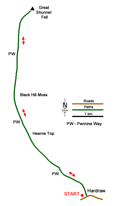
This North Yorkshire walk takes you to the summit of Great Shunner Fell (716 metres), the third highest mountain in the Yorkshire Dales National Park. This linear route uses the Pennine Way which makes navigation an easier task than it might be when you consider the terrain.
The start is the village of Hardraw where limited roadside parking is available at the west end of the village (grid ref. SD865912). After parking walk towards the village. Turn left onto the Pennine Way (signed Thwaite and Cotterdale). You now have about 7 kilometres following the Pennine Way to the summit of Great Shunner Fell. Initially the path follows a walled track. The track climbs steadily and where the walled track ends after 1.5 kilometres, you reach open country (grid ref. SD857921).
A few metres later the track forks. Take the left fork staying on the Pennine Way. The clear track continues to climb across the moor. For a brief section there is a wall on your immediate left and after passing the section of wall, the gradient steepens. Reaching a gate (grid ref. SD848932). Go through the gate, pass a sheepfold on your left, and shortly after turn right still following the Pennine Way.
The way ahead is still easy to follow rising across a wild moorland landscape. As you approach Great Shunner Fell's summit the path bears to the right and a wonderful view opens up for you to enjoy. Highlights of the panorama include Swaledale with its patchwork of green fields and hay barns and the view west to Wild Boar Fell. If like me, you have frequently walked in this area you will be able to identify many of the places you have walked in the past.
With the hard work now over you can retrace your route back to the start at Hardraw. With very few exceptions the path is downhill all the way and you can relax and enjoy the view to the south across Wensleydale to the higher ground of Three Peaks Country.
Messaging & Social Media
Message Walking Britain and follow the latest news.

Mountain Weather
Stay safe on the mountains with detailed weather forecasts - for iOS devices or for Android devices.