Thornham Circular Walk
Walk 3640 - Route Maps
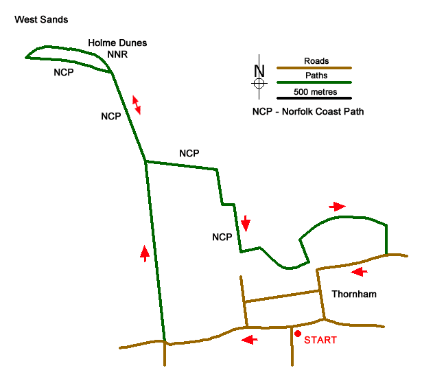
Route Map
Digital Maps - Copyright © 2011-2024. All rights reserved.
Sketch Map
Suggested Maps 

| Ordnance Survey Explorer 250 | Sheet Map | 1:25k | BUY |
| Anquet OS Explorer 250 | Digital Map | 1:25k | BUY |
| Ordnance Survey Landranger 133 | Sheet Map | 1:50k | BUY |
| Anquet OS Landranger 133 | Digital Map | 1:50k | BUY |
It is recommended you take a map. The preferred scale is 1:25k.
Start Point Details
Ordnance Survey Grid Ref TF731433
Latitude 52.959134 Longitude 0.575614
Postcode PE36 6LX
what3words start firewall.captures.battle
Walk description may contain detailed information on the start point for this walk.
Further Information
Norfolk
The county of Norfolk lies in Eastern England. Its northern and eastern boundaries are the North Sea and to the northwest, The Wash. Norfolk is a largely rural county and well-known for its network of rivers and lakes known as the Broads. This area is not a national park although it has a similar status to a national park. Norfolk's low-lying land and easily eroded cliffs, many of which are composed of chalk and clay, make it vulnerable to weathering by the sea with the coast between Kelling and Lowestoft Ness in Suffolk the most at risk. Norfolk is a popular tourist area with several major attractions. There are many seaside resorts, with some having Britain's finest beaches including those at Great Yarmouth, Cromer and Holkham. In addition to protected area of the Broads, there is also the Norfolk Coast National Landscape (formerly AONB). Many areas of the coast are wild bird reserves. Tow national trails, The Norfolk Coast Path and The Peddar's Way.
Walk grading - Learn how each walk is assessed and select a walk to suit your ability and experience by going to Walk Grading Details.
Messaging & Social Media
Message Walking Britain and follow the latest news.

Mountain Weather
Stay safe on the mountains with detailed weather forecasts - for iOS devices or for Android devices.