Walk 3659 - printer friendly version
Scar House Reservoir, Dale Edge & Middlesmoor Walk
Author - Lou Johnson
Length - 9.0 miles / 14.6 km
Ascent - 1400 feet / 424 metres
Grade - moderate
Start - OS grid reference SE092743
Lat 54.1644230 + Long -1.8605930
Postcode HG3 5ST (approx. location only)
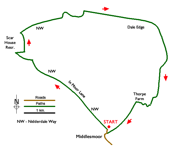
This North Yorkshire walk from Middlesmoor in Nidderdale completes a circuit around the lip of Nidderdale offering fine views across the beautiful valley and surrounding moorland. The route follows tracks and paths and includes Scar House Reservoir, uses sections of the Nidderdale Way, and descends to the River Nidd on the return leg back to Middlesmoor.
The start is the small car park at the northern end of Middlesmoor village (grid ref. SE092743). After parking exit the car park and turn right to join the Nidderdale Way which heads northwest. The route follows In Moor Lane for four kilometres to reach Scar House Reservoir. The route climbs steadily across the moor before descending to the shore of Scar House Reservoir (grid ref. SE064766).
Turn right along the reservoir still following the Nidderdale Way and then bear left across the dam. Once across the dam, the route climbs away from the reservoir and then turns right onto Carle Fell Road (grid ref. SE065772). Follow this clear track across the hillside for just over 1.5 kilometres to cross Woo Gill (grid ref. SE078777). 500 metres beyond Woo Gill where the Nidderdale Way forks right, bear left and climb past the Shooting House to reach a T-junction with a clear track (grid ref. SE085779).
Bear left along the track with fine views into Nidderdale on your right. Continue ahead on this track around Dale Edge for approximately five kilometres to reach another Shooting House (grid ref. SE102751). Turn right just before the Shooting House and continue down towards Thorpe Farm (grid ref. SE102751) where you meet the Nidderdale Way.
Turn right and just past the farm (on your left) turn left and descend to cross the River Nidd (grid ref. SE101751). Turn left and follow the path south with the river on your right. After 150 metres fork half right at a path junction and follow the rising path heading south-west back to Middlesmoor. The path passes through a small plantation, crosses Intake Gill, and reaches the road at the southern end of Middlesmoor near the Parish Church. Reaching the road, turn right through the village back to the car park.
Messaging & Social Media
Message Walking Britain and follow the latest news.

Mountain Weather
Stay safe on the mountains with detailed weather forecasts - for iOS devices or for Android devices.