Walk 3673 - printer friendly version
Rawlsbury Camp, Lower Ansty, Hilton & Bulbarrow Walk
Author - Lou Johnson
Length - 7.2 miles / 11.7 km
Ascent - 900 feet / 273 metres
Grade - easy/mod
Start - OS grid reference ST783059
Lat 50.8522050 + Long -2.3096327
Postcode DT11 0HQ (approx. location only)
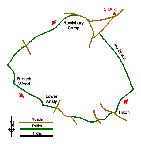
This Dorset walk explores the area south west of Bulbarrow Hill. The route is full of scenic interest in an area that must have been visited by Thomas Hardy. The walk crosses the earthworks of Rawlsbury Camp before following a section of the Wessex Ridgeway to the village of Lower Ansty. A section of woodland walking through the Links Plantation takes you to Hilton with its fine parish church. A section along the Ice Drove takes you back to the start.
The start is the parking area and viewpoint on Woolland Hill (grid ref. ST783059). After parking walk to the road junction and take the lane signed to Stoke Wake, which is a section of the Wessex Ridgeway. Keep straight ahead at the next junction (grid ref. ST774058) and again at the next junction soon after. Take the bridleway on the left after 100 metres signed to Dorset Gap. Stay on the bridleway to cross the remains of Rawlsbury Camp. Continue along the bridleway descending to reach a road by Crockers Farm (grid ref. ST756050).
Cross the road and continue along the bridleway to reach a T-junction of tracks. Turn left and follow the track as it skirts Breach Wood (on your left). At the end of the frees turn left and follow Cothayes Drove in a south-easterly direction. Continue past Cothayes Farm. %00 metres beyond the farm turn left along a signed footpath (grid ref. ST761033) which leads over a stile to a road in Lower Ansty. (The Fox Inn a short way up the road to the left is a suitable stop for refreshments).
From the stile take the road opposite (Aller Lane) and walk for 600 metres to reach a right-hand bend. Leave the road here at a fingerpost (grid ref. ST769029). Immediately go through the gap in the hedge on your right and go half left across the field. Enter the Links Plantation and follow the path through the trees. Leave the trees and head uphill to reach a road (grid ref. ST777028). Cross the road and follow the continuing path down through more trees to reach Church Row in Hilton (grid ref. ST781029).
Bear right and follow the path through the churchyard of All Saints to exit on a lane (grid ref. ST782030). Go straight ahead and join a lane, The Knapp, which soon becomes a track. Follow this bridleway for just over a kilometre and turn left onto the Ice Drove (grid ref. ST788037). Continue along this bridleway for two kilometres to a road (grid ref. ST778054). Turn right and return to the start of the walk.
Messaging & Social Media
Message Walking Britain and follow the latest news.

Mountain Weather
Stay safe on the mountains with detailed weather forecasts - for iOS devices or for Android devices.