Walk 3675 - printer friendly version
Bedlam and Great Elm from Mells Walk
Author - Lou Johnson
Length - 4.7 miles / 7.6 km
Ascent - 350 feet / 106 metres
Grade - easy/mod
Start - OS grid reference ST730491
Lat 51.2404330 + Long -2.3881565
Postcode BA11 3PQ (approx. location only)
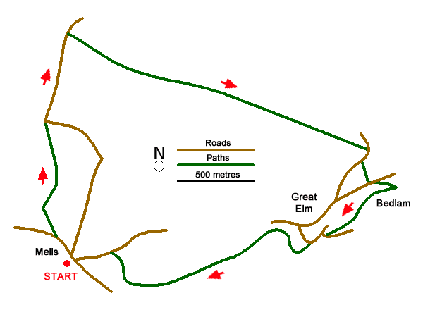
This Somerset walk starts from the village of Mells offers an interesting walk with varied content. The walk crosses fields to join a disused railway which is followed in an easterly direction for three kilometres. The route continues to Bedlam where a valley path through woodland continues via Great Elm back to the start.
There is limited on street parking on Selwood Street in Mells (grid ref. ST730491). If you are a patron then the Talbot Inn offers a parking alternative. After parking walk east along Selwood Street and turn left into Fairview. After a short distance turn left at the fingerpost, cross the stile, and walk half right across the field to the rear of the churchyard and a footpath junction (grid ref ST728494). Cross the path in an avenue of trees and continue north across two fields to a gap in a hedge. Turn left along the edge of the third field (with hedge on left) and follow the path around two sides of the field to reach a lane (grid ref. ST728500).
Continue straight ahead along the lane for 700 metres to reach a bridge over the disused railway (grid ref. ST730506). Turn left off the lane and then right under the bridge to follow the cycleway for about two kilometres. The cycle path leads to a lane (grid ref. ST751498). Turn right and follow the lane for a short way and turn left through a metal gate with an adjacent fingerpost. Go straight across the field to reach a stile which leads onto Hapsford Road. Turn right and almost immediately left down a narrow lane (signed as a no through road). Descend the lane down into the Wadbury Valley, cross the small stone bridge over the river and turn right along the East Mendip Way (grid ref. ST754495).
Follow the path for 700 metres to a lane, keeping the river on your right. Turn right along the lane, cross the bridge, follow the lane around to the left and climb the hill between houses. At the top of the hill where the road bends right, continue ahead on a track which leads to a path. Descend through trees down towards the river. Follow the path which eventually widens to a track. Continue upstream with the river on your left to reach a road (grid ref. ST733490). Turn left along this road. Reaching a junction, turn right and pass in front of the Post Office to return to the start.
Messaging & Social Media
Message Walking Britain and follow the latest news.

Mountain Weather
Stay safe on the mountains with detailed weather forecasts - for iOS devices or for Android devices.