Walk 3678 - printer friendly version
Brampton & the Bure Valley from Buxton Walk
Author - Lou Johnson
Length - 6.0 miles / 9.8 km
Ascent - 150 feet / 45 metres
Grade - easy/mod
Start - OS grid reference TG232228
Lat 52.7566760 + Long 1.3062538
Postcode NR10 5ET (approx. location only)
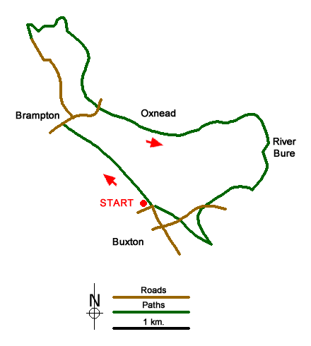
This pleasant Norfolk circular walk starts from Buxton and follows the 15-inch gauge Bure Valley Path alongside the 15-inch gauge Bure Valley Railway to reach Brampton. From here the route continues through this attractive village to reach the banks of the River Bure where a riverside path is followed back to Buxton (Norfolk).
The start is the car park at the end of Stracey Road (grid ref. TG232228) which is adjacent to the Bure Valley Railway station. After parking cross the railway and turn left to follow the clear path alongside the railway. After 1.5 kilometres of easy walking, you reach Brampton station. After crossing a bridge over a road, turn right and descend to the road (grid ref. TG222239). At the road, bear left and continue ahead into the village of Brampton.
After 100 metres, fork left onto 'The Street' opposite the phone box on your right. Follow the road through the village going straight one at the junction along a lane signed as a no through road. The lane turns left and then right past St Pater's Church and continues to the gates of Brampton Hall at the end of the lane (grid ref. TG219247). Continue ahead initially on a concrete track which soon becomes a path. Cross a small wooden footbridge, ignore the second bridge on the left and continue ahead to reach a larger footbridge across the River Bure. A short diversion across the river leads to St Mary's Church in Burgh-next-Aylsham.
To continue the walk, turn right before the larger footbridge to the church and follow the riverside path (River Bure on your left). Continue past the weir where you fork left through a gate with a stile. Keep the river to your left and continue to a small wood. You can detour through the wood or stay on the riverside path. Reaching Oxnead Bridge (grid ref. TG226240). Cross the road via kissing gates on either side to continue with the River Bure to your left. You soon pass Oxnead Hall on the other side of the river. From here you have another three kilometres of riverside walking eventually passing the church at Lamas across the river. Shortly after the path nears Buxton Mill where you join a driveway. Turn left and continue to a lane (grid ref. TG238229).
Cross the lane and pass through a gate to continue along the riverside path. Just before reaching the railway bridge across the River Bure, go through a gate, cross a footbridge, and turn sharp right up steps to re-join the path beside the Bure Valley Railway. Turn right (north) and continue back to the start with the railway on your left.
Messaging & Social Media
Message Walking Britain and follow the latest news.

Mountain Weather
Stay safe on the mountains with detailed weather forecasts - for iOS devices or for Android devices.