Walk 3691 - printer friendly version
Scout Moor from Ashworth Moor Reservoir Walk
Author - Shanita Lee
Length - 4.5 miles / 7.3 km
Ascent - 700 feet / 212 metres
Grade - easy/mod
Start - OS grid reference SD830159
Lat 53.6393360 + Long -2.2585957
Postcode OL12 7TY (approx. location only)
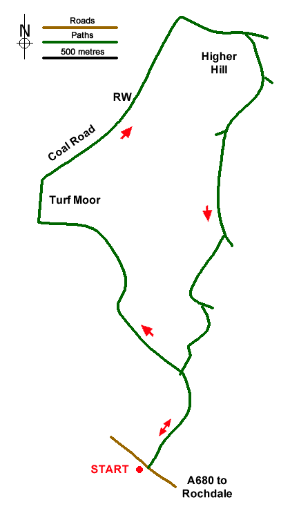
The start is the parking area on the south side of the A680 overlooking Ashworth Moor Reservoir (grid ref. SD830159). After parking, cross the road with care and take the rough path/track to the right of the no motorcycles sign. Follow the route passing Cheesden Fold on your left across Tom Hill to reach a junction of paths/tracks on Turf Moor (grid ref. SD824175). Turn right here and after 300 metres turn right onto the Coal Road (Rossendale Way). Continue up the valley containing Grain Brook. At the head of the valley, turn right (grid ref. SD833187) and continue across the northern side of Higher Hill with its radio mast. You are now passing through the Scout Moor Wind Farm.
After passing the radio mast bear right at a junction of tracks (grid ref. SD837186) and head south. Keep the first wind turbine to your right, bear right at the next junction and continue along the clear track. At the next junction continue ahead soon passing another turbine on your right. Just after the next turbine, fork right and continue past a turbine on your left (grid ref. SD833171). Leave the track as it bends to the left and follow a grassy path heading south which soon passes through walled fields to re-join the outward route.
Messaging & Social Media
Message Walking Britain and follow the latest news.

Mountain Weather
Stay safe on the mountains with detailed weather forecasts - for iOS devices or for Android devices.