Walk 3719 - printer friendly version
Ramsden Wood & Hades Hill from Walsden Walk
Author - Lou Johnson
Length - 6.1 miles / 9.9 km
Ascent - 900 feet / 273 metres
Grade - easy/mod
Start - OS grid reference SD928213
Lat 53.6881010 + Long -2.1105007
Postcode OL14 7UW (approx. location only)
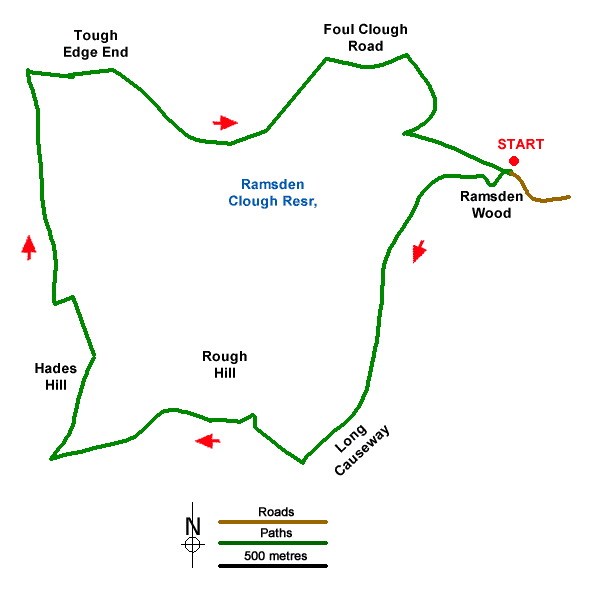
This circular Calderdale walk starts from Ramsden Wood near Walsden. The route explores an upland area following Long Causeway across the flank of Rough Hill before joining the Rossendale Way across Hades Hill to reach Trough Edge End. The walk returns to the start through Ramsden Wood. There are fine views throughout the walk of this wild landscape that was once home to coal and lead mining.
To reach the start leave the Rochdale Road (A6033) in Walsden and turn west up Ramsden Wood Road at grid ref. SD934214. Continue for 650 metres to where the road swings sharp right and bear left up Ramsden Lane opposite a yellow grit box on the right. Continue up the unsigned lane where a small parking area can be found by a small reservoir (grid ref. SD928213). After parking continue up Ramsden Lane as it bends left and then right. Continue to a fork by Plantation Barn (grid ref. SD924213). Fork left here and after 180 metres turn right through a gale signed Long Causeway.
The clear path climbs steadily across the south flank of Ramsden Hill. After 1.5 kilometres you reach a gravel service road for the wind turbines. Cross this track and after 200 metres turn right at a stone marker. 400 metres beyond the marker stone you head left across a stream following yellow arrows (grid ref. SD914200). The path briefly follows a wall (on your left). Keep right along the rising path that leaves the wall to pass through quarry spoil heaps. After the last spoil heap, bear left and follow the path beside the wall for 800 metres. On your right should be another gravel track serving the wind farm.
At the end of the wall (grid ref. SD903198), turn right onto the Rossendale Way, which heads north. Keep the quarry on your right and continue across Hades Hill. Descend a short way and fork left to follow a wall. After 350 metres the Rossendale Way turns left and then a short way after turns right with a wall on your left. Continue north for 700 metres to reach a cross path (grid ref. SD902219). Turn right and head half right across rough grass to join the Todmorden Centenary Way (grid ref. SD904218).
Continue ahead passing the trig point at Trough Edge End. From the trig point head south-east to pass the ruin of Coolam Farm (grid ref. SD911215) on your right. You have now re-joined the Todmorden Centenary Way (CCW) which is followed for 1.5 km. past Pot Oven to reach Brown Road Farm. The CCW turns right here and continues south to reach Ragby Bridge (grid ref. SD923216). Just before the bridge turn left through a gate with yellow waymarks through Ramsden Wood following a narrow path. Continue back to the start.
Messaging & Social Media
Message Walking Britain and follow the latest news.

Mountain Weather
Stay safe on the mountains with detailed weather forecasts - for iOS devices or for Android devices.