Walk 3731 - printer friendly version
Chaddleworth from Great Shefford Walk
Author - Lou Johnson
Length - 8.0 miles / 13 km
Ascent - 500 feet / 152 metres
Grade - easy/mod
Start - OS grid reference SU382753
Lat 51.4753780 + Long -1.4513705
Postcode RG17 7EJ (approx. location only)
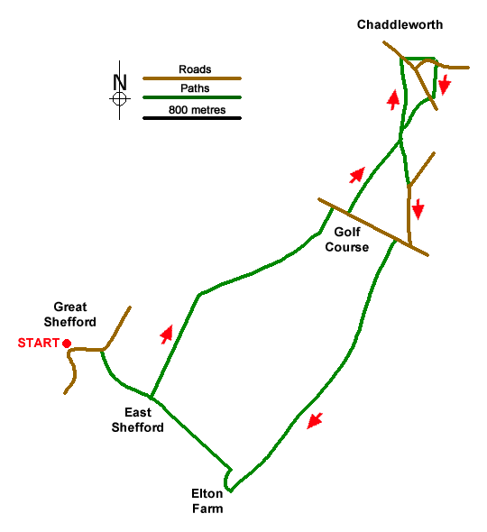
A Berkshire walk from Great Shefford in the Lambourn Valley exploring the downs to the north-west of the village. The route uses bridleways and paths to cross an undulating landscape to reach the village of Chaddleworth with its remarkable church. The return route turns south to the Lambourn Valley, and you should allow time to visit the second notable church of the walk at East Shefford.
The start is the centre of Great Shefford where on street parking is available in Church Street (grid ref. SU382753). Do remember to park with consideration. After parking follow Wantage Road (A338) north out of the village and continue to just after the filling station on the right. Turn right down the waymarked tarmac drive along the Lambourn Valley Way (grid ref. SU386753) to East Shefford Farm (grid ref. SU389749). Turn left past barns onto a rising track.
Continue up the track for 700 metres to a finger post (grid ref. SU3947570. Turn right and follow waymarked path (yellow arrows) across fields and then along side a golf course to a road, Buckham Hill (grid ref. SU407764). Cross the road and follow the path beside a hedge (initially on the right then on the left). Continue ahead at a three-way fingerpost (grid ref. SU412771). 150 metres beyond the fingerpost go half left across fields to reach a road in Chaddleworth (grid ref. SU4111778).
Turn right and continue across the road junction to St. Andrew's Church. After visiting the church return to the road junction and turn left. After 100 metres turn left through a gate onto a signed footpath (grid ref. SU412778). Follow the path through parkland by Chaddleworth House. The path loops round to re-join the road by the village hall.
Cross the road and follow the path across a field to a road (grid ref. SU414774). Turn right and almost immediately left to take the footpath signed to Waylands. Continue ahead to reach the three-way fingerpost passed earlier in the walk (grid ref. SU412771). From here go half left and continue to a road (Sheephouse Way). Turn right and continue to a T-junction (grid ref. SU412762).
Turn right and then left past the Golf Clubhouse. Continue beside the golf course (on your right) soon joining a track (Elton Lane). Follow this track for just over two kilometres to descend into the Lambourn Valley. Turn right past Elton Farm and then left on the Lambourn Valley Way, which is the route of a former railway line. Continue to East Shefford (grid ref. SU389749). A short diversion to the left takes you to St. Thomas's church, East Shefford. To complete the walk, retrace your steps from East Shefford along the Lambourn Valley Way back to the start.
Messaging & Social Media
Message Walking Britain and follow the latest news.

Mountain Weather
Stay safe on the mountains with detailed weather forecasts - for iOS devices or for Android devices.