Walk 3761 - printer friendly version
Cefn Bryn & Three Cliffs Bay from Penmaen Walk
Author - Lou Johnson
Length - 9.0 miles / 14.6 km
Ascent - 1300 feet / 394 metres
Grade - moderate
Start - OS grid reference SS531888
Lat 51.5788650 + Long -4.1214298
Postcode SA3 2HE (approx. location only)
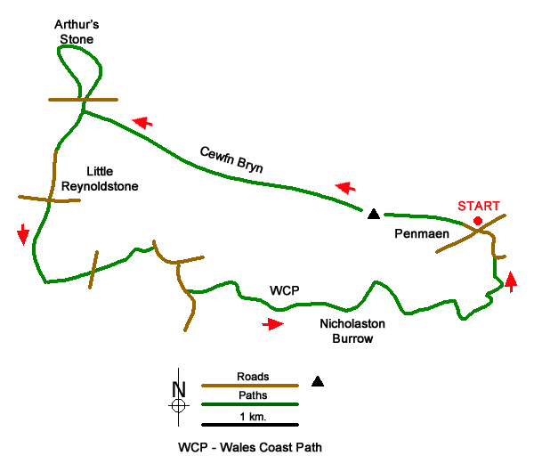
This walk in the Gower Peninsula starts from Penmaen and crosses the moorland ridge of Cefn Bryn, which offers excellent views to the coast. The route continues to Arthur's Stone the site of a neolithic burial chamber. From here the walk descends and passes through woods and the parkland of Penrice Castle. More woodland leads to the coast and a section of the Wales Coast Path which is used to return to the start via Three Cliffs Bay. The relevant OS Explorer map is useful for this walk.
The walk starts from the small National Trust car park (grid ref. SS531888) which lies up a lane between the bus stop and church on the north side of the A4118. After parking, trace you steps a short way and head sharp right to join a tarmac track. At the next fork, bear left and follow the path (Gower Way) as it climbs steadily onto the ridge. There are many minor paths and if in doubt keep to the brow of the ridge. The first landmark is the OS trig column which marks the highest point of the walk.
The onward path descends to a broad col with several paths and tracks (grid ref. SS513891). Keep ahead following the path up the crest of the ridge over Cefn Bryn. The undulating path crosses two minor tops before descending again to a broad col (grid ref. SS500896). Continue ahead and keep to the crest of the ridge to pass a topograph on your right, which can be reached by a short diversion off the main path. Return to the main path and continue to the road (grid ref. SS493900). Cross the road and walk through the parking area and walk north on a grassy path to Reach Arthur's Stone.
Retrace your steps back to the road. Cross the road and follow the main ridge path for 150 metres (before reaching the topograph) and turn right (south) down a grassy path. Continue to a road in Reynoldston. Turn left and continue to reach the A4118. Cross the A4118 and take the track opposite. The track soon enters Mill Wood and descends into the valley. Continue to a junction by a pool (grid ref. SS489882) and turn left. Follow this track to a gate and a road.
Cross the road and stile in a stone wall (grid ref. SS493883). Cross the stile and join the drive through Penrice Castle Park. The route through the park is waymarked with yellow markers and leads to the A4118. Turn right, and with care, follow the road for 250 metres to the first junction on the right by the Lodge. Turn right and descend into the valley. As you descend a wall comes in on the right-hand side of the road. At this point turn left up a gravel track (the footpath sign is on the side of the track). This track leads through Nicholaston Woods. Reach a fork, keep right on the lower track, and continue to reach the Wales Coast Path (grid ref. SS520880).
Bear left along the Wales Coast Path through dunes, woodland, and wetland. Ignore paths off to the right and continue ahead on the main path. Continue past Nicholaston Burrows and Penmaen Burrows to reach Three Cliffs Bay. Note that the remains of a medieval church and another neolithic burial chamber are located a short way off the coast path at Penmaen Burrows. Reaching the sand at Three Cliffs Bay, turn left up to a track leading to Notthill. Reaching a wider track, turn left and continue up to a junction. Turn left again and return to the A4118 and the car park.
Messaging & Social Media
Message Walking Britain and follow the latest news.

Mountain Weather
Stay safe on the mountains with detailed weather forecasts - for iOS devices or for Android devices.