Tintagel to Boscastle
Cornwall AONB Walk
Region - Cornwall AONB
County/Area - Cornwall
Author - Lou Johnson
Length - 9.0 miles / 14.6 km Ascent - 1970 feet / 597 metres
Time - 6 hours 30 minutes Grade - moderate
Maps 

| Ordnance Survey Explorer 111 | Sheet Map | 1:25k | BUY |
| Anquet OS Explorer 111 | Digital Map | 1:25k | BUY |
| Ordnance Survey Landranger 190 | Sheet Map | 1:50k | BUY |
| Anquet OS Landranger 190 | Digital Map | 1:50k | BUY |
| Ordnance Survey Landranger 200 | Sheet Map | 1:50k | BUY |
| Anquet OS Landranger 200 | Digital Map | 1:50k | BUY |
Walk Route Description
Click image to visit gallery of 2 images.
This Cornwall walk combines a superb section of Cornish coastline and one of the prettiest fishing harbours in England with a rural section including the woodland of St Nectan's Glen. This is not an easy walk and after rain the section through the Glen can be very muddy.
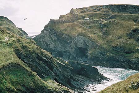
The start is Tintagel (grid ref. SX 057884), which some may say has suffered too much commercialism from its connections with the Arthurian legends. Parking is adequate and apart from on the busiest days you should find a space in one of the pay and display car parks. After parking locate the main street and the picturesque old post office. Walk in northerly direction towards the sea with the old post office on your left and descend towards the castle. Not much remains of this castle and you perhaps get a better view from the coastal path as you head eastwards towards Boscastle. Turn right off the track along the coastal footpath, which is clearly signed. Quite soon you will have escaped from the crowds and are able to enjoy the scenery.
The coastal path keeps fairly close to the cliffs and offers excellent views throughout. The first major headland is Willapark ( not to be confused with another Willapark which overlooks Boscastle harbour) from where the path drops to Bossiney before climbing up again to the cliff tops. Ahead is a superb succession of fine headlands. If there is a heavy sea then the drama can be quite inspiring as the waves crash onto the shore.
Another descent takes you down into Rocky Valley from where the scenery becomes noticeably more rugged, especially the rocky spires off Trevalga Cliff. Rocky Valley is a delightful spot with some waterfalls on the stream, which we shall more of later in St Nectan's Glen. As with all coastal walking you are now faced with a steep climb back to the top of the cliffs as you head towards Firebeacon Hill.
The switchback nature of the path continues with another descent and ascent at Welltown brings you to the second Willapark. Staying on the coastal path you drop down to southern side of the beautiful harbour. In contrast to Tintagel the commercialisation has had less impact on the immediate surrounds what is one of the prettiest harbours in England and it is worth spending some time here.
To leave the village cross the main road and head south on the lane that runs in front of the Wellington Hotel. You climb steeply and climb up steeply taking the left fork to pass the post office. Cross straight over the B3266 to reach Paradise and turn right at the next cross-roads. Follow this lane almost back to the main road (Grid ref. SX 096905) before turning left down a farm track. Immediately after the track turns sharp right and sharp left, cross the stile on your right and head across fields to reach a farm track, which leads onto a lane (Grid ref. SX 092895).
Turn right along the lane for a short way and a few yards past the entrance drive to Trehane Farm turn left onto a track and immediately right over a stile. Cross the field to a lane and turn left. Pass Tredole Farm and just past it locate the waymarked path (Grid ref. SX 091892). This leads down over fields to the stream that we crossed in Rocky Valley.
With the stream on your left continue on the path towards St Nectan's Glen. Take care to follow the correct route past a ruined barn to reach the site of the old Hermitage tea-garden. At the third footbridge turn left to cross it and follow the path up the side of the wooded valley to Halgabron. After leaving the woodland cross a field to reach a lane. Turn right along the lane and approximately 150 metres take the footpath on the your left. This leads in westerly direction across fields to reach the main road in Bossiney.
Turn left along the main road towards Tintagel. After about 200 metres Locate the footpath on your right (Grid ref. SX 065888) and follow this to the coast to rejoin your outward route. Turn west along the coast to reach Barras Nose where a short diversion will provide a good view of the remains of Tintagel Castle. Continue uphill into the main street and the end of the walk.
Other walks nearby
| Walk 1883 | Advent Church | easy | 5.2 miles |
| Walk 1808 | Brown Willy, exploring Cornwall's highest Tors | easy/mod | 4.0 miles |
| Walk 3279 | Tors of Bodmin Moor | moderate | 10.0 miles |
| Walk 3264 | Port Quin & Port Isaac Circular | easy/mod | 5.7 miles |
| Walk 2730 | St Gennys & Castle Point from Crackington Haven | easy/mod | 3.0 miles |
| Walk 2731 | Cambeak & Crackington Haven | easy/mod | 4.3 miles |
| Walk 2462 | The Rumps & Pentire Point | easy/mod | 4.0 miles |
| Walk 1076 | Dizzard Point & Crackington Haven | moderate | 8.0 miles |
| Walk 3755 | Dizzard Point, Millook from Penhalt Cliff | moderate | 6.0 miles |
| Walk 3738 | Polzeath & Pentire Point from Rock | moderate | 11.4 miles |
Recommended Books & eBooks
Walking in Cornwall
 This guidebook includes routes to 40 day walks in Cornwall. From short, easy strolls to longer, wilder routes, there is plenty to appeal to both families and experienced walkers. The walks explore the interior and coasts, including walks through picturesque villages, old tin-mining areas and the Lizard and Land's End Peninsulas.
More information
South West Coast Path Map Booklet - St Ives to Plymouth
 Map of part of the southern section of the 630 mile (1014km) South West Coast Path National Trail. Covers the trail from St Ives to Plymouth along the west Cornwall and Devon coastline. This convenient and compact booklet of Ordnance Survey 1:25,000 maps shows the route, providing all of the mapping you need to walk the trail in either direction.
More information
Messaging & Social Media
Message Walking Britain and follow the latest news.

Mountain Weather
Stay safe on the mountains with detailed weather forecasts - for iOS devices or for Android devices.