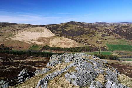
Housey Crags from Langleeford
Northumberland Walk
Nat Park - Northumberland
County/Area - Northumberland County
Author - Lou Johnson
Length - 2.0 miles / 3.3 km Ascent - 650 feet / 197 metres
Time - 1 hours 40 minutes Grade - easy/mod
Maps 

| Ordnance Survey Explorer OL16 | Sheet Map | 1:25k | BUY |
| Anquet OS Explorer OL16 | Digital Map | 1:25k | BUY |
Walk Route Description
Click image to see photo description.
Although short, this linear walk from Langleeford offers spectacular views across the highest summits in the Northumberland National Park. The highest hill, the Cheviot, lies just across the Harthope Burn valley and is connected to other summits along the ridge. The route climbs steadily up the hillside to visit two volcanic outcrops of Housey Crags and nearby Long Crags. This walk can easily be extended by including Walk 2152 - Harthope Linn (waterfall).
The route starts from a small grassy roadside parking area on the road from Wooler into the Harthope Burn valley about 600 metres before Langleeford Farm (grid ref. NT953225). After parking take the path south (with adjacent fingerpost) beside a stone wall on your right. Cross the Harthope Burn and start the steady climb up the northern flank of Hedgehope Hill. The two objectives of the walk, Housey Crags and Long Crags, are both in view ahead. The permissive path makes a beeline for Housey Crags with the view improving as height is gained.
Clambering to the top of Housey Crags, you look down one the Harthope Burn valley. On the far side of the valley, New Burn and Hawsen Burn drain the slopes of Blackseat Hill diagonally from left to right below the peak of Broadhope Hill. After enjoying the view continue up the path to Long Crags from where you can enjoy a similar view. After enjoying the view retrace your steps back to the start.
Other walks nearby
| Walk 1766 | Cushat Law and Bloodybush Edge from Hartside | mod/hard | 12.5 miles |
| Walk 2299 | The Cheviot | moderate | 9.0 miles |
| Walk 1314 | Great Hetha and Elsdon Burn from Hethpool | easy/mod | 4.0 miles |
| Walk 3644 | Blackhaggs Rigg & Great Hetha from Hethpool | moderate | 9.6 miles |
| Walk 3646 | Hethpool, Sutherland Bridge & Great Hetha | moderate | 6.0 miles |
| Walk 3739 | Elsdonburn & Trowupburn from Hethpool | moderate | 8.2 miles |
| Walk 1805 | An introduction to the Breamish Valley | easy | 2.0 miles |
| Walk 2677 | Circuit of Doddington Moor | easy | 3.8 miles |
| Walk 1201 | Black Hag from Kirk Yetholm | moderate | 8.5 miles |
| Walk 1200 | Windy Gyle | moderate | 7.5 miles |
Recommended Books & eBooks
Walking in Northumberland
 This guidebook contains detailed route descriptions for 36 day walks in Northumberland including the Cheviot Hills. The terrain varies from wild walks and craggy ascents to gentle riverside strolls. Each route ranges from 4 to 16 miles in length and there is the opportunity to link several walks together to create longer treks.
More information
Hadrian's Wall Path
 Hadrians Wall Path guidebook to walk the 84 mile National Trail. Described in both directions, the main description is west to east between Bowness-on-Solway and Wallsend, Newcastle, with extensions to Maryport and South Shields. With extensive historical information related to this World Heritage site and separate 1:25,000 OS map booklet included.
More information
Messaging & Social Media
Message Walking Britain and follow the latest news.

Mountain Weather
Stay safe on the mountains with detailed weather forecasts - for iOS devices or for Android devices.