Semer Water, Stalling Busk & Marsett
Yorkshire Dales Walk
Nat Park - Yorkshire Dales - Wensleydale
County/Area - North Yorkshire
Author - Lou Johnson
Length - 4.0 miles / 6.5 km Ascent - 400 feet / 121 metres
Time - 2 hours 20 minutes Grade - easy
Maps 

| Ordnance Survey Explorer OL30 | Sheet Map | 1:25k | BUY |
| Anquet OS Explorer OL30 | Digital Map | 1:25k | BUY |
Walk Route Description
Click image to see photo description.
Starting from the shores Semer Water, this walk explores the farming communities of Stalling Busk and Marsett. The route uses field paths, Busk Lane, and short section of lane. Along the way the walk passes a ruined chapel and enjoys views across Semer Water and the surrounding countryside. This walk can be combined with Walk 3524 from Bainbridge.
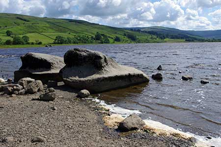
The start is a parking area by the shore of Semer Water (grid ref. SD922875). Like Malham Tarn, this is a natural lake formed in a side valley off Wensleydale. After parking, face the lane and turn right. Continue along the lane to Low Blean Farm and turn right at the fingerpost through a gate. You are now following the Pennine Journey long distance path for the first section of the walk. The path crosses several stiles to reach the lake shore. A further series of stiles leads past the ruined chapel of Stalling Busk on your right. Just after the chapel ruins fork left and follow the beck which leads you into the hamlet of Stalling Busk (grid ref. SD916859).
Just after the Church of St. Matthew on the left, turn right along a rough track, Busk Lane. Continue along the enclosed track to reach a ford over Cragdale Water. If the water is high, bear right before the beck and cross using a footbridge. Continue along the track, using the footbridge on the left to cross Raydale Beck. Continue into Marsett. Just past the first building on the left, veer right across grass to cross Marsett Bridge (grid ref. SD903862). Follow the lane for about 1.5 kilometres enjoying a view across the lake and ahead to shapely Addlebrough (hill). Take the first footpath on the right by a finger post with a yellow top. Cross the stile and bear half left along a path that crosses fields to reach a lane by Semer Water Bridge. Turn right across the bridge back to the start.
Other walks nearby
| Walk 3524 | Semer Water and Cam High Road from Bainbridge | easy/mod | 5.7 miles |
| Walk 2363 | Drumaldrace (Wether Fell) from Burtersett | easy/mod | 5.2 miles |
| Walk 2822 | Aysgarth & Castle Bolton | mod/hard | 14.5 miles |
| Walk 1694 | Nappa Hall & Whitfield Gill Force | easy/mod | 6.0 miles |
| Walk 2273 | Dodd Fell Hill & Drumaldrace | moderate | 11.5 miles |
| Walk 2286 | Gayle & Aysgill Force from Hawes | easy | 3.5 miles |
| Walk 3624 | Great Shunner Fell from Hardraw | mod/hard | 9.2 miles |
| Walk 3621 | Great Shunner Fell & Lovely Seat | mod/hard | 11.4 miles |
| Walk 2155 | Mossdale & Cotterdale | easy/mod | 7.9 miles |
| Walk 1680 | Haw Lane & Aysgarth Moor | easy/mod | 6.3 miles |
Recommended Books & eBooks
Walking in the Yorkshire Dales: South and West
 Part of a two-book set, this guidebook describes 44 walks in the southern and western Yorkshire Dales, including the famous 23 mile Three Peaks circuit over Pen-y-Ghent, Whernside and Ingleborough. The other, mostly circular routes of 3½ to 13 miles cover the scenic region between Sedbergh, Kirkby Lonsdale, Settle, Skipton and Grassington.
More information
Trail and Fell Running in the Yorkshire Dales
 Guidebook to 40 of the best trail and fell runs in the Yorkshire Dales National Park. Ranging from 5 to 24 miles, the graded runs start from bases such as Ribblehead, Dent, Sedbergh, Malham and Grassington and take in the region's diverse delights, from castles and waterfalls to iconic mountains such as Whernside, Ingleborough and Pen Y Ghent.
More information
Messaging & Social Media
Message Walking Britain and follow the latest news.

Mountain Weather
Stay safe on the mountains with detailed weather forecasts - for iOS devices or for Android devices.