Wyre Valley Circular from Abbeystead
Forest of Bowland Walk
Region - Forest of Bowland
County/Area - Lancashire
Author - Lou Johnson
Length - 6.4 miles / 10.4 km Ascent - 600 feet / 182 metres
Time - 3 hours 50 minutes Grade - easy/mod
Maps 

| Ordnance Survey Explorer OL41 | Sheet Map | 1:25k | BUY |
| Anquet OS Explorer OL41 | Digital Map | 1:25k | BUY |
Walk Route Description
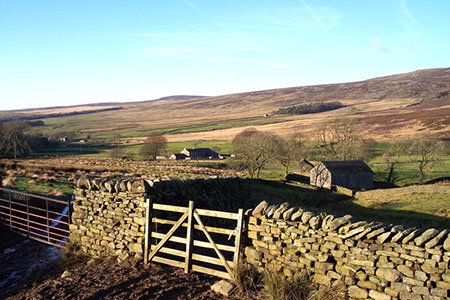
Click image to see photo description.
This Lancashire walk starts from the village of Abbeystead and follows the Wyre Way for the whole route. The walk climbs onto the fringes of the moors of the Forest of Bowland before turning west to follow the valley of the Marshaw Wyre which is a tributary of the River Wyre. Generally, the route is easy to follow with waymarking in place at all key points along the way.
The start is the small car park at Stoops Bridge at the eastern end of Abbeystead village beside the River Wyre (grid ref. SD563544). After parking return the short distance to the road junction and turn right up Straight Lane. Where the road bends left after 400 metres take the footpath straight ahead through waymarked garden gate to continue along the Wyre Way. Continue with woodland on your right and then maintain direction across fields to reach a stile and a lane (grid ref. SD575547).
Go straight across the road and follow the access drive to Top of Emmetts. The path veers off right just before the house and then heads in a north-easterly direction across fields to reach a lane at Tarnbrook (grid ref. SD587556). Turn right and at the end of the buildings fork left onto a clear track to continue along the Wyre Way. The open country to your left is some of the moorland of the Forest of Bowland. Stay on the track to reach Gilberton after 800 metres. Turn left in front of the house and continue, initially along a track.
The path bends right and then heads south passing between barns at Speight Clough. Continue south, with wall right and continue past a stand of trees on your left. At the end of the trees the path swings southeast to join a track (grid ref. SD603542). Bear right along the track and follow it south through trees through a metal gate to the road at Tower Lodge (grid ref. SD604539).
Turn right along the road. Follow the road for 2.6 kilometres passing Marshaw Farm on your right. Keep straight ahead at a junction near Well Brook. Where the road bends to the right continue straight ahead following the waymarked Wyre Way (with fence on your left). The path veers right to skirt woodland on your right and then continues by following the River Marshaw Wyre. The path crosses several footbridges and eventually leads to a lane. Turn right and the car park is a short walk away.
You can extend the walk. Instead of turning right to the car park, turn left and follow Walk 3459 to complete a circuit of Abbeystead Reservoir and finish with a stroll through the attractive and well-maintained village.
Other walks nearby
| Walk 1742 | Grit Fell from the Jubilee Tower near Quernmore | moderate | 7.7 miles |
| Walk 2164 | Clougha Pike from the Jubilee Tower | easy/mod | 4.7 miles |
| Walk 3038 | Wolfhole Crag from Tower Lodge | moderate | 9.0 miles |
| Walk 2257 | Clougha Pike from Quernmore | easy/mod | 4.8 miles |
| Walk 2137 | Clougha & Goldsworthy's Installation Circular | moderate | 5.2 miles |
| Walk 1218 | Fiensdale Head & Bleasdale Water | moderate | 10.0 miles |
| Walk 2594 | Totridge Fell & Fiendsdale Head, Forest of Bowland | moderate | 11.0 miles |
| Walk 1670 | Hazelhurst Fell, Fair Snape Fell and Parlick | moderate | 11.0 miles |
| Walk 1994 | Cockerham, Glasson & Conder Green | easy/mod | 6.6 miles |
| Walk 3505 | Whitewell via Crag Stones from Dunsop Bridge | easy/mod | 8.5 miles |
Recommended Books & eBooks
Walking on the West Pennine Moors
 This guidebook describes 30 walks on the West Pennine Moors, around Blackburn, Darwen, Chorley and Bolton, home to some of the most inspiring and exhilarating walking country. The walks range from short, easy rambles to more challenging hikes covering a variety of terrain, all of it easily accessible for day walking.
More information
Walking in the Forest of Bowland and Pendle
 A guidebook to 40 diverse circular day walks suitable for walkers with navigational skills. The Forest of Bowland and Pendle are two of north west England's upland AONBs, perfect for walkers who enjoy exploring rough hilly, sometimes pathless terrain. The routes include Ward's Stone, Pendle Hill, Longridge Fell and Fair Snape Fell.
More information
Messaging & Social Media
Message Walking Britain and follow the latest news.

Mountain Weather
Stay safe on the mountains with detailed weather forecasts - for iOS devices or for Android devices.