Clougha & Goldsworthy's Installation Circular
Forest of Bowland Walk
Region - Forest of Bowland
County/Area - Lancashire
Author - Lou Johnson
Length - 5.2 miles / 8.5 km Ascent - 1000 feet / 303 metres
Time - 3 hours 40 minutes Grade - moderate
Maps 

| Ordnance Survey Explorer OL41 | Sheet Map | 1:25k | BUY |
| Anquet OS Explorer OL41 | Digital Map | 1:25k | BUY |
Walk Route Description
Click image to see photo description.
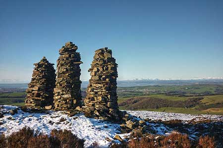
A circular walk near to Lancaster exploring an area of moorland rising to Clougha Pike (413 m.) in the north-western sector of the Forest of Bowland. The route starts from Littledale and follows an anti-clockwise circuit of Clougha passing by an impressive trio of cairns and visiting the Andy Goldsworthy installation. The are can be confusing in poor visibility and even in clear weather the relevant OS 1:25000 map is a useful addition to your pack. In fine weather there are excellent views to Morecambe Bay and the Lake District Fells.
The walk starts from the Littledale Road car park (grid ref. SD547618). After parking, exit the parking area and turn left along the lane. Just before the cattle grid, turn right and cross the ladder stile. Follow the grassy track half left across the field. Continue into the next field and keep the wall on your left. Bear left at a wall corner and keep close to the wall. Follow the grassy track as it bends right and continue in the next field with the wall on your right. Continue ahead to Skelbow Barn (grid ref. SD551613). Continue between walls soon turning right to reach a gate. Stay on the grassy track to cross a ladder stile (grid ref. SD550611).
Once over the stile, bear right along a path running parallel to the wall on your right. Continue on this path for 300 metres after which the path splits. Keep to the right-hand path now walking parallel to Cragg Wood on your right. This path soon leads to a clear track (grid ref. SD541612). Turn left along the track and follow the clear route as it twists and turns climbing onto the highest part of the moor. Off this track to the right are the three stone men (cairns). Continue for three kilometres along the track to reach Andy Goldsworthy's Installation (grid ref. SD556595).
After visiting the installation, retrace your steps along the track for about 300 metres to a less-distinct cross path (grid ref. SD553596). Turn right and head north across the moor. The path is generally distinct and after just over a kilometre bears half left to run parallel with a wall on your right. The path heads down a gully to re-join the outward route at a ladder stile (grid ref. SD550611). From here retrace your steps past Skelbow Barn and back to the start.
Other walks nearby
| Walk 2257 | Clougha Pike from Quernmore | easy/mod | 4.8 miles |
| Walk 1742 | Grit Fell from the Jubilee Tower near Quernmore | moderate | 7.7 miles |
| Walk 2164 | Clougha Pike from the Jubilee Tower | easy/mod | 4.7 miles |
| Walk 2278 | Ward's Stone from Stoops Bridge | mod/hard | 13.0 miles |
| Walk 3459 | Abbeystead Reservoir Circular | easy | 1.6 miles |
| Walk 3457 | Wyre Valley Circular | easy/mod | 6.4 miles |
| Walk 3038 | Wolfhole Crag from Tower Lodge | moderate | 9.0 miles |
| Walk 1994 | Cockerham, Glasson & Conder Green | easy/mod | 6.6 miles |
| Walk 1641 | Bankhouses via the Lancashire Coastal Way | easy/mod | 7.0 miles |
| Walk 1218 | Fiensdale Head & Bleasdale Water | moderate | 10.0 miles |
Recommended Books & eBooks
Walking on the West Pennine Moors
 This guidebook describes 30 walks on the West Pennine Moors, around Blackburn, Darwen, Chorley and Bolton, home to some of the most inspiring and exhilarating walking country. The walks range from short, easy rambles to more challenging hikes covering a variety of terrain, all of it easily accessible for day walking.
More information
Walking in the Forest of Bowland and Pendle
 A guidebook to 40 diverse circular day walks suitable for walkers with navigational skills. The Forest of Bowland and Pendle are two of north west England's upland AONBs, perfect for walkers who enjoy exploring rough hilly, sometimes pathless terrain. The routes include Ward's Stone, Pendle Hill, Longridge Fell and Fair Snape Fell.
More information
Messaging & Social Media
Message Walking Britain and follow the latest news.

Mountain Weather
Stay safe on the mountains with detailed weather forecasts - for iOS devices or for Android devices.