Ruabon Mountain & The Limestone Edges of Llangollen
Denbighshire Walk
County/Area - Denbighshire
Author - Lou Johnson
Length - 11.0 miles / 17.9 km Ascent - 1400 feet / 424 metres
Time - 6 hours 50 minutes Grade - moderate
Maps 

| Ordnance Survey Explorer 256 | Sheet Map | 1:25k | BUY |
| Anquet OS Explorer 256 | Digital Map | 1:25k | BUY |
| Ordnance Survey Landranger 117 | Sheet Map | 1:50k | BUY |
| Anquet OS Landranger 117 | Digital Map | 1:50k | BUY |
Walk Route Description
Click image to see photo description.
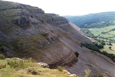
This a grand circuit despite some road walking at the beginning of the route. "Full of contrasts" is how the route is best described with a section of open moorland contrasting with the dramatic limestone edge that overlooks the River Dee and the town of Llangollen.
Parking near Trevor Rocks (grid ref. SJ 234432) provides a good place to start and from here follow the lane southeast. Turn left at the first junction (or take the footpath that cuts the corner) and continue on the lanes past Prospect Place, Cefn-y-fedw, and Hafod Farm. Then turn left for Bryn-Adda. At the end of this lane a footpath enters open moorland. Care is required for the next short stage. Keeping the same heading leave the Frozen Clock following the fence and low wall on your right. At the end of the wall bear left into the left field then keep close to its right hedge to drop down to a stile into the woods. A pleasant path descends to a footbridge. At the path junction (Grid ref. SJ 261456) turn left climbing up through the woods to its boundary to join a track. Turn right and follow this path should be followed around the western perimeter of the woods to reach a minor road (grid ref. SJ 263470). Turn left onto the lane and locate the footpath on the left about 300 metres up the lane.
This path leads across open moorland roughly due west to bring to World's End. Do not enter the plantation but skirt the perimeter heading first south and then west. This brings you onto the limestone edge on the upper level. Below is the Offa's Dyke Path, which skirts the base of the edge. There are many paths and tracks along the edge but it is best to stay as high as you can.
Although this may sound a very simple explanation the remaining three miles (5 km) of the walk are best completed by staying as high as you can following the clear path. To your right the view is superb including Castell Dinas and the River Dee meandering through the Vale of Llangollen. Arrival at Trevor Rocks and your transport is a straightforward exercise and you are left wondering whether this wonderful limestone escarpment really is North Wales!
Other walks nearby
| Walk 1845 | Castell Dinas Bran from Llangollen | easy/mod | 4.0 miles |
| Walk 2598 | Ruabon Mountain, World's End & Panorama Circular | moderate | 12.5 miles |
| Walk 2460 | Pontcysyllte Aqueduct Circular | easy | 4.5 miles |
| Walk 3655 | Rhewl, Moel y Gamelin & Moel Morfydd | moderate | 5.4 miles |
| Walk 2388 | Chirk Castle & Ceiriog Valley | easy/mod | 6.0 miles |
| Walk 1989 | Llanarmon Dyffryn Ceiriog Circular | moderate | 6.0 miles |
| Walk 3031 | Cadair Berwyn | moderate | 9.3 miles |
| Walk 1528 | Moel Famau | easy/mod | 10.0 miles |
| Walk 2905 | The Llangollen Canal from Ellesmere | easy/mod | 8.0 miles |
| Walk 1259 | Foel Fenli & Moel Famau from Loggerheads | moderate | 9.5 miles |
Recommended Books & eBooks
No suggestions for this area.Messaging & Social Media
Message Walking Britain and follow the latest news.

Mountain Weather
Stay safe on the mountains with detailed weather forecasts - for iOS devices or for Android devices.