Fair Brook & Kinder Downfall from Birchen Clough
Peak District Walk
Nat Park - Peak District - Kinder Scout Edale
County/Area - Derbyshire
Author - Mike Bexley
Length - 8.0 miles / 13 km Ascent - 1060 feet / 321 metres
Time - 5 hours 0 minutes Grade - moderate
Maps 

| Ordnance Survey Explorer OL1 | Sheet Map | 1:25k | BUY |
| Anquet OS Explorer OL1 | Digital Map | 1:25k | BUY |
| Ordnance Survey Landranger 110 | Sheet Map | 1:50k | BUY |
| Anquet OS Landranger 110 | Digital Map | 1:50k | BUY |
Walk Route Description
Click image to visit gallery of 3 images.
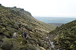
This Peak District walk explores the quieter areas of the Kinder Plateau yet still includes a visit to the popular Downfall. Like any good walk it includes a variety of terrain and begins with a riverside section. The route then climbs up alongside waterfalls ending with a boulder path to the plateau. After that it's the challenge of Kinder, which is why it is one of my favourite walks irrespective of season. A word of warning - care must be taken if Kinder is in cloud as it's so easy to get lost. In addition competence in the use of a compass is required to make the crossing of the Kinder plateau as for some of the time you are walking below ground level with no visible points of reference.
The start is the small car park at Birchen Clough on the A57 Snake Road (Grid ref. SK109914). Cross over the road (south) and go through the gate to follow the path through the woods down to a stream. Continue to follow this downstream turning left when it joins the River Ashop. Do not cross the footbridge on your left but instead stay on the north side of the river following the path that climbs back up to the main road. Follow the main road in the direction of Sheffield past the Snake Inn to take a signed footpath on the south side of the road that leads down to a footbridge (Grid ref. 114902). Cross the bridge and follow the river for a short way before turning right at the first brook, Fair Brook, to follow the tumbling waters upstream on to Kinder (Grid ref 093 891).
As you climb the views begin to open out and although the ascent looks daunting you soon reach the plateau. On arrival at the top you will see to your right the edge sticks out like a nose. This is Fairbrook Naze and it is a good place to eat a sandwich and watch the world go by. Rather surprisingly you will also notice the ground is sandy - a fact that justifies the claim there are "beaches" in the Peak District.
We have now to make the crossing over to Kinder Gates, which comprises of large stones each side of the shallow Kinder River (Grid ref 088 887). It is important you set your compass as at times you will be below ground level. At first follow the streambed as far as you can keeping a regular eye on your bearing. Providing you follow your compass in the general direction you will reach Kinder River and if you are good Kinder Gates! Do not follow any footprints as the owner may have been lost - just put your trust in your compass rather than any hunches. It is also quite easy to see someone ahead and follow them - don't - they may be wandering around in circles!
On reaching the River Kinder turn right and follow it downstream to the Downfall (Grid ref 083 889). This waterfall can be disappointing after dry weather but with the right conditions it can be spectacular. Whatever it is another stop to take in the views.
Now follow the wide path northwest from the Downfall. This keeps to the edge before dropping very steeply down some steps on Ashop Head towards the stake on Mill Hill. Reaching the cross path (Grid ref. 063902) turn right. Note - this is prior to climbing up to Mill Hill. You are now on the Snake Path, a very old right of way connecting Hayfield with the Snake Inn on the Snake Road. The name does not come from the twisting road but from the coat of arms of the Cavendish family, which featured a snake. Keep on this path reaching a stile into the woods and take the first path on the left climbing up to turn right on to a forest road this leads you back to the stream and the start.
Other walks nearby
| Walk 1489 | Blackden Brook, Kinder & Upper Ashop | moderate | 6.8 miles |
| Walk 3049 | Bleaklow Stones from Derwent Valley | mod/hard | 12.0 miles |
| Walk 1159 | Grindsbrook & Edale Head | moderate | 7.5 miles |
| Walk 1264 | Rushup Edge & Crowden Tower | moderate | 10.0 miles |
| Walk 1295 | Ringing Roger & Edale Cross | moderate | 10.0 miles |
| Walk 2595 | Castleton Great Ridge from Edale | moderate | 8.5 miles |
| Walk 2615 | The Kinder Edges | mod/hard | 18.0 miles |
| Walk 3350 | Kinder Scout Summit | moderate | 8.5 miles |
| Walk 1113 | Ringing Roger & Grindslow Knoll | moderate | 5.5 miles |
| Walk 1300 | Hope Cross & Ringing Roger | moderate | 8.0 miles |
Recommended Books & eBooks
Dark Peak Walks
 Guidebook to 40 walks in the Dark Peak area of the Peak District National Park. 35 circular routes for most abilities, from 8km to 19km, around Edale, Marsden, Fairholmes, Baslow and Castleton, including Kinder Scout and Mam Tor, and 5 longer (25km to 45km) routes highlighting the best of the Gritstone Edges, High Moorland and Deep Valleys.
More information
Pennine Way Map Booklet
 Map of the 270 miles (435km) Pennine Way National Trail, between Edale in the Peak District and Kirk Yetholm in the Scottish Borders. This booklet is included with the Cicerone guidebook to the trail, and shows the full route on Ordnance Survey 1:25,000 maps. This popular long-distance route typically takes three weeks to complete.
More information
Messaging & Social Media
Message Walking Britain and follow the latest news.

Mountain Weather
Stay safe on the mountains with detailed weather forecasts - for iOS devices or for Android devices.