Walk 1018 - printer friendly version
Beinn Ghobhlach Walk
Author - Lou Johnson
Length - 6.0 miles / 9.8 km
Ascent - 2400 feet / 727 metres
Grade - moderate
Start - OS grid reference NH059918
Lat 57.87335 + Long -5.2745576
Postcode IV23 2QP (approx. location only)
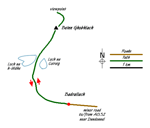
Rising to 635m Beinn Ghobhlach is a 'Graham' that occupies a stunning position in the peninsula between Loch Broom and Little Loch Broom in north-west Scotland. The start is at the end of the road in the village of Badrallach located on the north shore of Little Loch Broom. Badrallach is reached along a minor road that leaves the A832 a few miles southeast of Dundonnel.
The end of the road in Badrallach (grid ref. NH059918) offers very limited space for parking and you may have to use an alternative space back down the lane. After parking walk west along the well maintained footpath leading to the community of Scoraig, which despite its lack of roads has boomed in recent years. After about a kilometre on the path strike off uphill to the right aiming for the small col just to the east of the 338 spot height on OS maps. There are a few rough tracks used by farmers to gain access to the hills and these do ease the climb.
Reaching the col you get a clear view of the task in hand. Immediately below are Loch na Coireig (on the right) and Loch na h-Uidhe. Behind rise the steep southern slopes of Beinn Ghobhlach. The first task is to head for the strip of land between the two lochs and then tackle the slopes ahead. It can be boggy as you approach the lochs there is nothing that cannot be avoided. Once across the stream linking the two lochs the climb starts in earnest. There is no clear path and it is a case of finding the route that suits you to gain the ridge just to the west of the summit where you are rewarded with a superb 360 degree panorama. It is worth walking past the summit cairn and shelter to the top of the subsidiary summit at the northwestern end of the ridge.
To return to the start, retrace your steps perhaps taking time to explore Loch na h-Uidhe where the outlet stream tumbles over a superb waterfall. However do be aware that there are significant crags either side of the waterfall making a descent a tricky option. It is easiest to return to the strip of land between the lochs and follow your outward path back down to the main lochside path.
Messaging & Social Media
Message Walking Britain and follow the latest news.

Mountain Weather
Stay safe on the mountains with detailed weather forecasts - for iOS devices or for Android devices.