Walk 1019 - printer friendly version
Beinn an Dothaidh & Beinn Dorain Walk
Author - Jake Robertson
Length - 8.5 miles / 13.8 km
Ascent - 4100 feet / 1242 metres
Grade - moderate
Start - OS grid reference NN297395
Lat 56.516618 + Long -4.7695508
Postcode PA36 4AB (approx. location only)
Beinn Dorain is an iconic mountain, its huge sweeping cone shape a familiar sight to those travelling northwards along the A82 or the West Highland railway line. At 3530ft high it is a respectable height too but not the hardest of climbs and is most often combined with neighbouring Munro Beinn an Dothaidh. Despite the relatively large ascent this is not too difficult a walk, on a good day quite a pleasant one indeed with easy navigation and gradients, well within the capabilities of most.
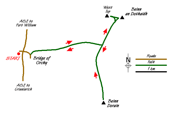
Park at the car park (grid ref. NN297395) by the Bridge of Orchy Hotel, cross the busy A82 and walk up the steep road to the train station (grid ref. NN301395). Go through the underpass and turn left through a gate. From here a clear, slightly eroded path curves around a mast and steadily climbs grassy slopes by the Allt Coire an Dothaidh for about 1000ft into Coire an Dothaidh. For what initially looks quite a drag the contours pass by fairly easily and quickly until the corrie is reached with some grand crags on either side. A steep zig-zag section through boulders and scree leads to the bealach at 774m (grid ref. NN325398), marked by a large cairn giving a delectable view down to Loch Lyon.
As both mountains are out and back walk from this col you are not committed to climbing them in any order or both of them. I prefer to climb Beinn an Dothaidh first and save Beinn Dorain, the finer of the two mountains, to last and if circumstance dictates and you only climb one mountain make it this.
A clear path slants up to the right on the north side of the col climbing through a rocky section into the grassy slopes of Coire Reidh where the path starts to lose itself near a small stream. Climb uphill aiming slightly to the left of the prominent top on the right, despite appearances this is not the highest point, and you should be soon on the ridge with the flat summit (1004m/3294ft) and cairn not too far ahead. It is not the most exciting of summits but there are wide views over Rannoch Moor. In bad weather it is best to return to the col by the same route but if it is clear, it is worth taking a short walk to the cairn on western top at 1000m (grid ref. NN327409); which has a much better airy prospect of the Black Mount hills. From this cairn veer back into Coire Reidh to rejoin the path back to the col.
The route up Beinn Dorain is obvious, straight up onto a rocky rib with a little easy scrambling before levelling out and veering right to a most picturesque little lochan (grid ref. NN323394). Continue south up a stiff scree slope which leads onto a bumpy ridge where the path splits. Ignore the tempting traverse path on the right as in mist it is all too easy to overshoot the main summit and become confused. Sticking to the ridge is by far the safer and better option bringing you up to a prominent cairn on the north top. A short descent and re-ascent along a pleasingly narrow ridge lead to the summit rocks and cairn at 1076m/3530ft (grid ref. NN325378). Although not quite the highest in the area this is a grand top and a fine viewpoint, surrounded almost entirely by mountains. The Glen Lyon hills to the east lead around to the Crianlarich hills with Ben More and Ben Lui dominating the southern skyline. Further west there is a lovely view down Glen Orchy to Ben Cruachan with the densely packed skylines of the Black Mount and Etive ranges, Bidean Nam Bian soaring above all and then hopefully on a clear day Ben Nevis, the Grey Corries, Creag Meaghaidh and Ben Alder filling the northern arc. It is well worth descending a little to the north for better views of the valley and the railway.
To return back to the Bridge of Orchy simply return back to the col along the north ridge then descend back down the path through Coire an Dothaidh, apart from the zig-zags in the coire it is a relatively painless and quick descent.
Messaging & Social Media
Message Walking Britain and follow the latest news.

Mountain Weather
Stay safe on the mountains with detailed weather forecasts - for iOS devices or for Android devices.