Walk 1038 - printer friendly version
Firle Beacon Walk
Author - Peter Smyly
Length - 13.3 miles / 21.5 km
Ascent - 1400 feet / 424 metres
Grade - moderate
Start - OS grid reference TQ430054
Lat 50.830479 + Long 0.029187131
Postcode BN8 6JS (approx. location only)
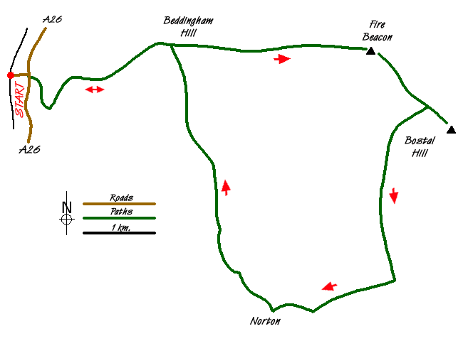
Walk 2419 (Southease, Ditchling Beacon and Lewes) featured a walk from Southease railway station, going west initially and this walk is in effect a follow-up to that walk by heading east from the same station along another section of the South Downs Way. Typically of the South Downs, much of the route is easy going along a broad grassy ridge of short grass with occasional gorse bushes, the route being either on the level or with gentle ups and downs and extensive views in different directions. Two car parks are also passed during the walk, therefore if you are using your own transport, you may wish to adjust the route accordingly.
Bostal Hill (191 metres) is the furthest point reached going east on this route from the start point. Therefore one option to complete the walk is to reverse the outgoing route. While a round trip is generally preferable in principle, to a "there and back", in this instance, the latter has certain advantages. Route-finding is straightforward, and you still have some of the best views on the walk from the main ridge.
Southease railway station is a small station on the Seaford Branch of the East Coastway Line. From the station, turn right along the road to the east and take a waymarked turning on the right for the "South Downs Way", passing Itford Farm on the left. The route soon crosses a busy main road over a wooden footbridge before turning first right, then left up the fellside. As the waymarkers then indicate, leave the main track and go on a diagonal traverse to the left up a sloping grassy felllside with grazing cows and calves. The path is rather vague in appearance for the next few hundred yards but the way ahead is clear. Looking to the left, the village of Southease, which gives its name to the station, can be seen to the west, with its church in particular standing out. More of the South Downs ridge to the west are seen beyond Southease. To the north, the River Ouse can be seen with the East Sussex town of Lewes beyond. The town of Seaford and the sea beyond are seen to the south.
On the approach to Itford Hill, the gradient steepens before easing off once the crest of the ridge is reached and a trig point off the path to the left appears alongside a saucer-shaped grassy depression. The metallic structures of the Radio Station on Beddingham Hill (190 metres) reveal the next objective about a mile distant to the east. Although unsightly in appearance, as a landmark, they stand out from afar.
From Beddingham Hill, Firle Beacon appears on the distant horizon to the east, reached by way of a gradual slope down to a car park first. In summer, the walk up the other side is noticeable for its carpet of flowers on the left. The trig point of Firle Beacon is several feet lower than the highest point. This is a fine viewpoint, though the view is even more revealing if you walk down the slope about thirty yards to the north to a barbed wire fence. From the fence you can see the more steep, sloping escarpment to the north which is not seen from the top. Apart from the patchwork of fields, woodland and rural settlements, the occasional train can be spotted and you may see parapenters hovering over the hill to the east of Lewes. There is also a good view looking back to Beddingham Hill and the sloping escarpment to the right helps lend perspective to give the landscape a more familiar South Downs profile.
On reaching it, the top of Firle Beacon is obviously the highest point on this stretch of the ridge and this is a good place to stop to look at the view. At 217 metres, 713 feet, Firle Beacon is one of several points on the South Downs over 700 feet and qualifies as a Marilyn, a mountain or hill in the United Kingdom with a relative height of at least 150 metres (492 ft). To continue the route, descend south-east to the next dip and car park before a much shorter walk this time than that between Beddingham Hill and Firle Beacon leads to the next hill top, Bostal Hill, which offers very similar views to the north compared with those seen from Firle Beacon.
Walking back down to the car park, there is a choice of return routes. While the most obvious and easiest option, in a route-finding sense, is to reverse the outgoing route, this walk route idea suggests taking a path to the left through a wooden gate. A grassy path runs alongside a fence on the left as it heads due south west then south for about a mile, passing through another wooden gate leading to a track with hedgerow and/or bushes either side. A sign here indicates that this is part of the Seaford Marathon route. Follow the way ahead until reaching an obvious fork in the path. Just before the fork, a wooden sign post on the right indicates a wooden stile and this is the way to go next. The path crosses a cultivated field, rather an improbable route on the face of it, leading to a narrow path between trees with encroaching nettles. This path soon emerges into the open over a wooden stile to emerge on a bridleway with Beacon Hill on the left and fields on the right. This bridleway leads to Norton where you need to take the tarmac road to the right (north) and shortly you come to the houses of Poverty Bottom. Soon after this, the tarmac road becomes an unsurfaced bridleway which in turn becomes a narrow footpath between trees, rising uphill before emerging into the open at a crossroads with a fine view of sloping fields, paths and hedgerows. Norton and Poverty Bottom are seen in retrospect. From the crossroads, a path to the north, trends north west at one point and leads to the main ridge, sometimes following alongside a fence or crossing open fields, to emerge about a hundred yards west of Beddingham Hill. It is now a straightforward task to return to Southease railway station by following this part of the outgoing route in reverse. On the way down you may find yourself passing an unlikely combination of cows and hang gliders since the slopes here are popular with the latter.
Messaging & Social Media
Message Walking Britain and follow the latest news.

Mountain Weather
Stay safe on the mountains with detailed weather forecasts - for iOS devices or for Android devices.