Walk 1043 - printer friendly version
Chelmorton & the Monsal Trail Walk
Author - Andy Chaplin
Length - 8.1 miles / 13.2 km
Ascent - 1000 feet / 303 metres
Grade - easy/mod
Start - OS grid reference SK115703
Lat 53.229618 + Long -1.8291882
Postcode SK17 9SN (approx. location only)
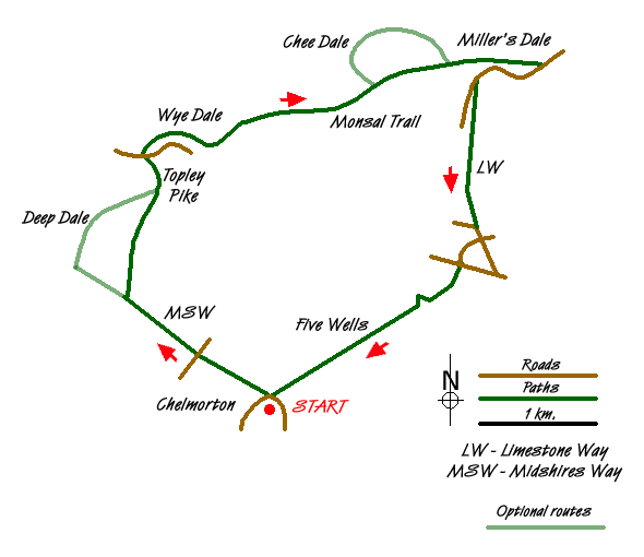
This circular Peak District walk combines the agricultural and industrial nature of the area. The walk can be extended by not using the opened Monsal Trail tunnels - i.e. by following the river path rather than the more direct old railway route.
Park on the main street near to the Church Inn (Grid ref. SK115703). Parking is limited but normally it is possible to park somewhere on the main street in Chelmorton. Please be careful not to block access to property.
Take the Midshires Way north west from The Church Inn towards Deep Dale. The landscape is typical of the area with Limestone walled fields. At Caxter Way Lane (Grid ref. SK101711) there are two options. First and more difficult is to continue ahead straight ahead following the Midshires Way. This leads down into Deepdale where you turn right once at the bottom of the dale. The easier option is to turn right on Caxter Way Lane to take a signed footpath on the right which leads down into Deepdale. Both options lead you to Topley Pike Quarry which you skirt around before crossing the busy A6 to Wye Dale. Today limestone quarrying is still a major industry in the area with Topley Pike being one of many active quarries.
Follow the path along Wye Dale to take the Monsal Trail into and along Chee Dale. Continue on this trail until reaching the former Millers Dale station. On the way you pass information boards about and examples of the old Lime Kilns. More information is available at the old Millers Dale station with history of the old railway line, the viaducts and the station. On this latter section you have two options. Firstly follow the trail. This is the easiest method. Alternatively follow the path along the river but note that this adds about half a mile to the route.
At Millers Dale station exit northwards through the yard onto the minor road then down to the B6049. At the B6049 turn right. You are about to follow the Limestone Way but note that initially it follows the road before heading left (Grid ref. SK133731) up Long Lane to Priestcliffe Road (Grid ref. SK134716). Turn right here and staying on the Limestone Way, cross the A6 again at the Waterloo Inn and continue ahead along Sough Lane. The lane changes from a track to a road as you pass through a gate and here you take the path along the wall south of Fivewells Farm and continue back to Chelmorton. The last part of the route is alongside an old lead-mining rake - which is a series of small excavations between the two paths - before coming back into the village near the old Illy Willy water supply.
Messaging & Social Media
Message Walking Britain and follow the latest news.

Mountain Weather
Stay safe on the mountains with detailed weather forecasts - for iOS devices or for Android devices.