Top Withins and the Bronte Bridge from Haworth
South Pennines Walk
Region - South Pennines
County/Area - West Yorkshire - South Pennines
Author - Lou Johnson
Length - 8.0 miles / 13 km Ascent - 850 feet / 258 metres
Time - 4 hours 50 minutes Grade - moderate
Maps 

| Ordnance Survey Explorer OL21 | Sheet Map | 1:25k | BUY |
| Anquet OS Explorer OL21 | Digital Map | 1:25k | BUY |
| Ordnance Survey Landranger 103 | Sheet Map | 1:50k | BUY |
| Anquet OS Landranger 103 | Digital Map | 1:50k | BUY |
| Ordnance Survey Landranger 104 | Sheet Map | 1:50k | BUY |
| Anquet OS Landranger 104 | Digital Map | 1:50k | BUY |
Walk Route Description
Click image to see photo description.
This walk covers some of the places and landscapes most associated with the Brontë family. Park in the car park close to the Brontë Parsonage (grid ref. SE 029373) in Haworth where Patrick Brontë was vicar. Family life for the Brontës was full of tragedy with Patrick outliving his son, five daughters and wife. The longest surviving daughters achieved considerable literary success with Charlotte's "Jane Eyre", Anne's "Agnes Grey" and Emily's "Wuthering Heights" all published in 1847. Despite the sadness the family endured today Haworth owes much to their lives and work.
From the car park make your way to the Church and take the path that runs to its right to pass the Parsonage Museum, which has a superb collection of artifacts pertaining to the Brontës. Follow the path signed to Haworth Moor which leads you onto a road. Turn left along the road and bear left at the first junction. After about 400 yards fork right to descend down a grassy track which leads to Lower Laithe Reservoir. Reaching the road follow it across the top of the dam, turning left at a T-junction to continue through the village of Stanbury.
At the far end of the village, turn left along an enclosed tarmac lane. The lane deteriorates into a rough track. Reaching a fork, take the right-hand route, which is signed "Top Withins". The track climbs steadily with improving views to emerge onto open moorland. Ignore diverging paths and stay with the main signed route to join the Pennine Way. This area could be confusing in bad weather and some experience of navigation would be useful in mist.
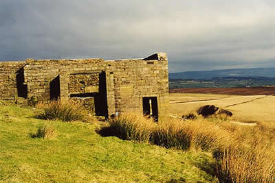
The ruined farmhouse of Top Withins is said by some to be Wuthering Heights but this is strongly disputed by experts. We shall never know the truth but the scenery is certainly superb and in wild weather the location is probably full of literary promise with superb views of the surrounding moorland. Although most people turn back for Haworth at this point it is worth pressing on for another half mile or so to reach the relative solitude of the less visited moors beyond the ruins.
From High Withins retrace your route towards Haworth for about two hundred metres and fork right along a path that heads in the direction of the Brontë Falls. The path descends through moorland with a stream to on your right. Follow the signs for the Falls crossing a number of walls which are crossed by stiles. Reaching a kissing-gate join the Brontë Way and descend to the Brontë bridge and falls. Reputed to be where the Brontë sisters spent some time the retrospective view is superb.
Cross the bridge and turn left towards Haworth following the main path that climbs above the stream. The onward route is straightforward first crossing moorland. The path becomes a track and leads to a public road. Turn right along the road for a short way before taking a path that heads half left to climb slightly onto the higher ground of Penistone Hill Country Park. There are many paths in this area but the best route is take the clear path that follows the ill-defined ridge and then skirts the northern flanks of Penistone Hill to reach a road (grid ref. 027368). Cross over and follow the path taking turning left to reach Haworth churchyard and the end of the walk.
Other walks nearby
| Walk 1585 | Haworth Moor circular | easy | 5.0 miles |
| Walk 1243 | Haworth Moor and Bronte Bridge from Oxenhope | easy | 3.5 miles |
| Walk 2705 | Oxenhope to Hebden Bridge without a car | moderate | 11.0 miles |
| Walk 1307 | Circuit of Ovenden Moor from Oxenhope | moderate | 8.0 miles |
| Walk 1449 | Cullingworth Circular | easy/mod | 6.3 miles |
| Walk 1584 | Ogden Reservoir | easy | 4.0 miles |
| Walk 3215 | Steeton to Ilkley without a car | moderate | 7.5 miles |
| Walk 1793 | Lothersdale | easy/mod | 6.0 miles |
| Walk 2661 | Keighley Moor Reservoir & Hitching Stone from Cowling | moderate | 9.5 miles |
| Walk 1952 | Five Rise Locks and the River Aire, Bingley | easy | 5.3 miles |
Recommended Books & eBooks
The Pennine Way
 Guidebook to the Pennine Way National Trail with OS map booklet. The 265 mile route from Edale to Kirk Yetholm takes three weeks to walk and is suitable for fit and experienced long distance walkers. The route crosses the Peak District, Yorkshire Dales and North Pennines National Parks. Includes separate OS 1:25,000 map booklet of the route.
More information
Pennine Way Map Booklet
 Map of the 270 miles (435km) Pennine Way National Trail, between Edale in the Peak District and Kirk Yetholm in the Scottish Borders. This booklet is included with the Cicerone guidebook to the trail, and shows the full route on Ordnance Survey 1:25,000 maps. This popular long-distance route typically takes three weeks to complete.
More information
Messaging & Social Media
Message Walking Britain and follow the latest news.

Mountain Weather
Stay safe on the mountains with detailed weather forecasts - for iOS devices or for Android devices.