Walk 1136 - printer friendly version
Yr Aran (Route 2) Walk
Author - Peter Smyly
Length - 5.5 miles / 8.9 km
Ascent - 2100 feet / 636 metres
Grade - moderate
Start - OS grid reference SH627506
Lat 53.035004 + Long -4.0490502
Postcode LL55 4NR (approx. location only)
I read somewhere recently that Yr Aran is Snowdonia's (Eryri's) least visited mountain. Two reasons appear likely. Firstly, walkers are more likely to be drawn by the lure of the bigger attraction of nearby Snowdon and, secondly, it's isolated position means it does not readily link up with any other mountains along a ridge. Having walked up Yr Aran recently (May 2011) I found it to be a fine mountain in it's own right and somewhat undeserving of its "neglected" position. As often happens with an isolated peak, the minus point of it not linking up readily with other nearby peaks comes with a corresponding plus point, the all-round views, and Yr Aran's top does command a fine 360 degree view with Snowdon and Y Lliwedd especially apparent.
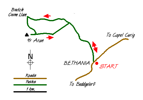
This Snowdonia walk starts at the car park at Bethania in Nantgwynant and heads up the Watkin Path across the road through woodland, the starting point of one of several routes up Snowdon. The path leads up through the trees, where horned goats may be seen, before emerging into the open. Continue along the Watkin Path as it goes to the left and then right past some waterfalls before leading to a valley with Snowdon ahead and Yr Aran to the left. Here a path leads off to the left and takes you up to the Bwlch Cwm Llan, the route becoming steeper and rockier as the bwlch draws nearer. At the bwlch (grid ref. SH605521), an even steeper path heads up Snowdon to the right. Ahead lie slate wastes and the remains of former quarry workings including a couple of small reservoirs. A walk across to the other side of the bwlch reveals a fine view of the Nantlle Ridge.
Looking towards Yr Aran from the bwlch, there appears to be no easy way up to the top. However, by following the dry stone wall ahead, a wooden stile over the wall marks a point where a clear path begins and which leads you all the way to the summit. The summit ridge is grassy with a few outcrops of rock, on one of which is a small pile of stones which marks the highest point. For the return route, by way of variation, descend down the steep rocky path to where the path forms "an elbow", but instead of turning left here to reverse the outgoing route, go straight ahead to follow a different path which broadly follows the line of a dry stone wall to the right. This path eventually disappears, but by now the Watkin Path can be seen below and it is a case of picking your own safe passage down steep, grassy, pathless slopes to rejoin it. Then follow the Watkin Path back down to the car park.
Messaging & Social Media
Message Walking Britain and follow the latest news.

Mountain Weather
Stay safe on the mountains with detailed weather forecasts - for iOS devices or for Android devices.