Walk 1143 - printer friendly version
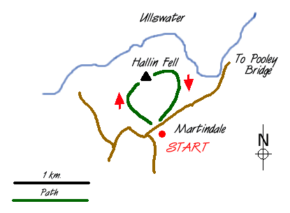
Hallin Fell Walk
Author - Lou Johnson
Length - 2.0 miles / 3.3 km
Ascent - 400 feet / 121 metres
Grade - easy
Start - OS grid reference NY435191
Lat 54.563958 + Long -2.8752953
Postcode CA10 2NF (approx. location only)
Not the most demanding Lake District fell walk but ideal with gale to storm force icy winds sweeping across the mountains. Described by Wainwright as a "motorists fell" it is an easy stroll to the summit of Hallin Fell (1272ft 388m) from the small car park (grid ref. NY 435191) adjacent to St Peter's church. Climbing in perfect light and visibility was easy on the lee side of the fell and the strength of the wind was not felt until the summit was neared. The last few yards had to be completed on hands and knees as the wind threatened to send us down into Martindale.
The summit cairn is a sturdy piece of stonework and provided enough shelter to admire the extensive views across the Lake District. Despite Hallin Fell's lowly stature, almost the whole of Ullswater can be seen, flanked on all sides by higher fells. We could see the snow being blown off Helvellyn and the other high tops to the west. Nearer to hand the fells of the High Street range shimmered with snow which had fallen the previous night. Away to the east the white tops of the Pennines could be easily seen in the clear cold air.
No detailed description of the walk is necessary. After parking by the church, follow your nose upward over pleasant grassy paths to the cairn. If time permits spend a few minutes to visit St Peter's Church - what a beautiful location for worship!
Messaging & Social Media
Message Walking Britain and follow the latest news.

Mountain Weather
Stay safe on the mountains with detailed weather forecasts - for iOS devices or for Android devices.