Walk 1148 - printer friendly version
Scout Scar from Sizergh Walk
Author - Stuart Holley
Length - 11.0 miles / 17.9 km
Ascent - 1200 feet / 364 metres
Grade - moderate
Start - OS grid reference SD501870
Lat 54.276196 + Long -2.7678239
Postcode LA8 8EX (approx. location only)
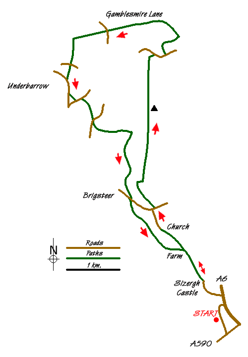
To start this Lake District walk it is best to park at a large deep lay-by on the minor road leading to Sizergh Castle, just after the junction with the A590 (Grid ref. SD502870). Walk into the grounds of Sizergh Castle following the road to the car park. Cross the car park to the far end and go through the gate, cross the track coming in from the left (your return route) and go through the gate opposite into a wide meadow with a well made-up footpath heading north west. Go through the gate and follow the farm track uphill, then take the footpath to the left through a wooded strip up toward Holeslack farm. There are N.T. Waymark signs.
Arriving at the farm access road, turn right (N.T. Walk signs indicate left) and after 50 metres cross the stile on the left and head uphill diagonally left to a ladder stile. In the next meadow continue uphill passing a wooded enclosure on the right, and aiming for the little church in the trees ahead of you. You will pick up a farm access road before reaching the church, and at the church turn right to head north along a tarmac lane. Here you will get a fine view of the Lyth Valley and the south western Lakeland fells.
At the end of the lane turn right onto the road, and after about 20 metres go through the gate on the left into more open country. Follow the track which bears left heading north west, passing through a gate and bearing right at the approach to a stone wall. Follow the path down into the valley leaving the wall behind, the path then swings left in the valley bottom, now heading north. Continue on this path, with the limestone escarpment on your right, until you reach a junction of paths where you take a sharp right back on yourself to climb up the side of the escarpment. As you enter more open ground continue forward until you meet a broad track (one of many along the top), turn sharp left heading north again, and then after about 100 metres turn right to gain further height and at another broad track turn left and head north to the O.S triangulation pillar just before a stone wall.
From here you can see the shelter with its "mushroom" roof. Go through the gap in the wall and follow any of the tracks leading to the shelter. Inside the rim of the shelter roof there is a 360 degree diagram enabling the identification of the Lakeland fells, the Howgills and many more.
From the shelter head north to pick up the path that leads down to the road and cross toward the car park opposite. Take the footpath just to the right of the car park entrance, follow this uphill and around to the left, skirting the transmitter enclosure, to meet up with another track where you turn left and follow to a gate in a stone wall. Cross the meadow heading north east until you meet the intersection with Gamblesmire Lane, where you turn left and go through the gate in the wall to follow this lane. Initially it passes through open country, (with an old limekiln to the right) then through gates into farm meadows, then through woodland and finally between high hedgerows, coming out at a minor tarmac road.
Cross the road and follow the waymarks across open country, heading generally west, finally descending to a another tarmac lane opposite a small house with an elaborate garden.
Turn left and head south along this lane until you reach the road. Here you can either go straight on along a byway, or turn right and head for the Punch Bowl pub in Underbarrow.
The byway comes out on another road where you bear left, and if you visit the pub, turn left as you leave and then left again onto the same road, heading south east.
At a dip in the road take the signed footpath on the left into a back garden and almost immediately out again into the adjoining meadow, head right uphill and right again, through another garden (!) to reach a road. Turn left and after about 150 metres take the signed footpath on the right. Cross diagonally left, over a stream bridge and a style, then bear right diagonally to a gate. Go through this and head diagonally left to leave this meadow by the corner gate, not via the style in the wall to the right. A short lane brings you to the road, turn left and then right after about 50 metres, pass to the right of some houses and to the left you can see the gate leading into the woods, head uphill across the open ground and enter the wood. Follow the path to a forestry road, bear right and soon leave the road onto an uphill path into the wood again. The path crosses a long meadow to re-enter the wood and uphill on what looks like a stream bed, through a gate then right and diagonally uphill to leave the farm buildings on the left.
The farm track is not a right of way, and just after a stone wall you take the path on the right through a pleasant woodland, going parallel to the farm track and re-joining it further down.
The track leads you out onto the road where you turn right and head downhill toward Brigsteer. Take the signed track on the left after about 100 metres, heading back south west, and stay with this track to eventually go through a gate into more open ground. Continuing in the same direction, you will encounter the N.T. Signs of the waymarked walks around the Sizergh estate.
At a junction of these tracks you have the choice of the shorter route to the left which will take you back via Holeslack Farm and your outward path, or bear right through the gate to cross the open meadows, passing a wooded enclosure, down to a track where you turn left, through a gate, and follow the lane back to the Sizergh car park and tea shop.
Messaging & Social Media
Message Walking Britain and follow the latest news.

Mountain Weather
Stay safe on the mountains with detailed weather forecasts - for iOS devices or for Android devices.